
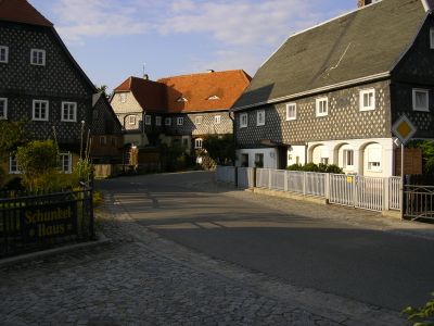
Obercunnersdorf, human settlement in Germany
Location: Kottmar
Elevation above the sea: 358 m
GPS coordinates: 51.03111,14.67222
Latest update: May 11, 2025 01:05
Hauptstraße 75
141 m
Im Winkel 3
67 m
Hauptstraße 78
214 m
Hauptstraße 108
81 m
Alte Schulgasse 1
153 m
Hauptstraße 99
75 m
Im Winkel 4
50 m
Am Dorfbach 5
207 m
Hauptstraße 86
111 m
Hauptstraße 101
90 m
Hauptstraße 80
180 m
Hauptstraße 90
78 m
Hauptstraße 91
26 m
Hauptstraße 87
67 m
Hauptstraße 84
134 m
Hauptstraße 103
132 m
Hauptstraße 105
135 m
Hauptstraße 106
66 m
Hauptstraße 89
38 m
Extinguisher station Hauptstraße
196 m
Hauptstraße 110
91 m
Hauptstraße 112
109 m
Hauptstraße 116
165 m
Hauptstraße 120
225 m
Im Winkel 1
93 m
Am Wehr 7
110 m
Alte Schulgasse 9
217 m
Alte Schulgasse 7
209 mReviews
Visited this place? Tap the stars to rate it and share your experience / photos with the community! Try now! You can cancel it anytime.
Discover hidden gems everywhere you go!
From secret cafés to breathtaking viewpoints, skip the crowded tourist spots and find places that match your style. Our app makes it easy with voice search, smart filtering, route optimization, and insider tips from travelers worldwide. Download now for the complete mobile experience.

A unique approach to discovering new places❞
— Le Figaro
All the places worth exploring❞
— France Info
A tailor-made excursion in just a few clicks❞
— 20 Minutes