
Totenbrettergruppe, um 1900; südwestlich bei Straßenkreuzung
Location: Prackenbach
Address: Straßenkreuzung
GPS coordinates: 49.11534,12.85045
Latest update: November 14, 2025 19:32
Kapelle
396 m
Bauernkapelle
1.4 km
Kapellenbildstock
1.3 km
Cultural heritage D-2-6843-0018 in Prackenbach
985 m
Schloßbauer
1 km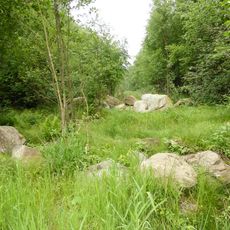
Solifluktionsblöcke im Prackenbachtal
846 m
Waldlerhaus
33 m
Zugehöriger stattlicher Traidkasten mit Giebelschrot
1.2 km
Zugehöriger stattlicher Traidkasten mit Giebelschrot und Flachdach
859 m
Einzelhof
1.1 km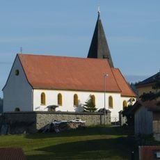
St. Peter und Paul
989 m
Wohnstallhaus
144 m
Friedhofsmauer In Krailing in Prackenbach
990 m
Kleines Waldlerhaus
1.2 km
Kapelle
927 m
Großes Wohnstallhaus
1.5 km
Beinhaus In Krailing in Prackenbach
976 m
Kleinhaus
1.2 km
Totenbrett Ruhmannsdorf 7 in Prackenbach
396 m
Einfirsthof
43 m
Ausnahmshaus mit Traidkasten und Remise
931 m
Inhaus
883 m
Marter In Steinhof in Prackenbach
928 m
Blockbau
1.2 km
Wayside cross
211 m
Wayside shrine
931 m
Wayside cross
395 m
Wayside cross
127 mReviews
Visited this place? Tap the stars to rate it and share your experience / photos with the community! Try now! You can cancel it anytime.
Discover hidden gems everywhere you go!
From secret cafés to breathtaking viewpoints, skip the crowded tourist spots and find places that match your style. Our app makes it easy with voice search, smart filtering, route optimization, and insider tips from travelers worldwide. Download now for the complete mobile experience.

A unique approach to discovering new places❞
— Le Figaro
All the places worth exploring❞
— France Info
A tailor-made excursion in just a few clicks❞
— 20 Minutes