Thác Bản Coóng, Wasserfall in Vietnam
Location: Bắc Kạn
Elevation above the sea: 341 m
GPS coordinates: 22.37694,105.81694
Latest update: March 3, 2025 03:10


Hùng Temple
123.5 km
Ban Gioc–Detian Falls
107.2 km
Nhật Tân Bridge
142.9 km
Nui Coc Lake
89.7 km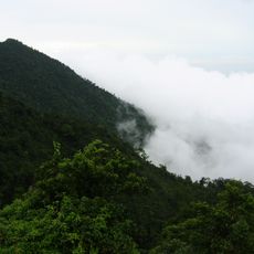
Tam Đảo
96.5 km
Thăng Long Bridge
142.4 km
Co Loa Citadel
140.8 km
Phật Tích Temple
144.1 km
Friendship Pass
102.5 km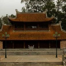
Son Tay Ancient Citadel
141.6 km
Chùa Vĩnh Nghiêm
139.6 km
Thanh Trì Bridge
142.4 km
Ham Long Buddhist temple
140.3 km
Tam Dao National Park
99.6 km
Ba Bể National Park
21 km
Viet Tri Stadium
126.4 km
Rock Paintings of Hua Mountain
123.6 km
Nguom Ngao Cave
105.2 km
Tra Linh checkpoint
75.9 km
Longbang Port
76 km
Ky Cung Bridge
113.4 km
Thanh Chuong Viet Palace
122.5 km
Vat Bridge
117.8 km
Thác Bà Lake
109.4 km
Sông Bé Bridge
144.9 km
大王岩岩画
141.2 km
Ha Giang provincial museum
99.4 km
Hoang Su Phi Terraced Rice Fields
124.7 kmReviews
Visited this place? Tap the stars to rate it and share your experience / photos with the community! Try now! You can cancel it anytime.
Discover hidden gems everywhere you go!
From secret cafés to breathtaking viewpoints, skip the crowded tourist spots and find places that match your style. Our app makes it easy with voice search, smart filtering, route optimization, and insider tips from travelers worldwide. Download now for the complete mobile experience.

A unique approach to discovering new places❞
— Le Figaro
All the places worth exploring❞
— France Info
A tailor-made excursion in just a few clicks❞
— 20 Minutes