Kimsbury House, house in Upton St. Leonards, Stroud, Gloucestershire, UK
Location: Upton St Leonards
GPS coordinates: 51.81530,-2.19739
Latest update: November 27, 2025 15:57
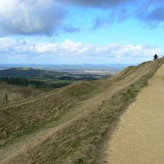
Painswick Hill (or Kimsbury) camp
987 m
Range Farm Fields
1.4 km
Teckels Cottage
1.4 km
Thatch Cottage
1.4 km
Castle Godwyn
1.5 km
Spoonbed Farmhouse
794 m
Primrose Cottage
1.2 km
Barn To North East Of Gastrells Farmhouse
1.2 km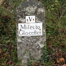
Milestone alongside B4073 at SO8663011731
1.3 km
Gazebo And Blow Family Memorials
834 m
Barn To North West Of Manor Farmhouse
1.3 km
Manor Farmhouse
1.3 km
Barn To North East
1.4 km
Dovecote to north of Holcombe House
1.6 km
Castle Godwyn
1.5 km
Cider House And Stable To South East Of Gastrells Farmhouse
1.2 km
Milestone, Painswick Beacon; 150m S beacon turn
1.3 km
Upper Holcombe Farmhouse And Attached Outbuilding
1.5 km
Cockpit At Yew Tree Mount
1.5 km
The Knapp
1.1 km
Valley Farmhouse
1.4 km
Maytree Cottage
1.1 km
Command Post At Croft Farm
1.1 km
Gastrells Farmhouse
1.2 km
Painswick Golf Course
1.4 km
Prinknash Bird and Deer Park
1.5 km
Cud Hill
753 m
Scenic viewpoint
943 mReviews
Visited this place? Tap the stars to rate it and share your experience / photos with the community! Try now! You can cancel it anytime.
Discover hidden gems everywhere you go!
From secret cafés to breathtaking viewpoints, skip the crowded tourist spots and find places that match your style. Our app makes it easy with voice search, smart filtering, route optimization, and insider tips from travelers worldwide. Download now for the complete mobile experience.

A unique approach to discovering new places❞
— Le Figaro
All the places worth exploring❞
— France Info
A tailor-made excursion in just a few clicks❞
— 20 Minutes