Hazelwood Farm, agricultural structure in Reigate and Banstead, Surrey, UK
Location: Reigate and Banstead
GPS coordinates: 51.30165,-0.16955
Latest update: November 21, 2025 11:18
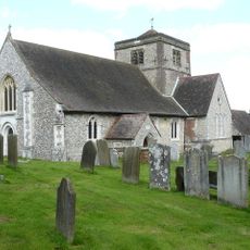
Church of St Margaret, Hooley
1.2 km
Shabden Park
1.3 km
Banks Tomb 15 Yards North Of Church Of St Margaret
1.2 km
Little Family Tomb 4 Yards South Of Church Of St Margaret
1.2 km
Ivy Cottage
440 m
Shabden Cottages
736 m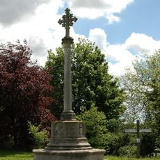
Chipstead War Memorial
1.2 km
Walpole Monument 25 Yards South Of Church Of St Margaret
1.2 km
Shabden Cottages
702 m
Coal Tax Post At Junction With Bridge Way Tq 27515783
446 m
Leyfields
749 m
Coal Tax Post 300 Yards South Of Hazelwood Lane And Opposite Brixham
678 m
Coal Tax Post Opposite Yew Tree Close
416 m
Shabden Cottages
777 m
Chest Tomb 20 Yards South Of The West End Of Church Of St Margaret
1.2 km
Court Lodge
1.1 km
Old Schoolhouse
821 m
Rumbold Castle Cottage
602 m
Wellhouse Opposite Nos 5-8 (Consec) (Shabden Cottages)
705 m
Post At Junction With Hollymead Road Ngr Tq 28545800
1 km
Coal Tax Post At Junction Of Hollymeoak Road, Portnall's Road, Rickman Hill And Hollymead Road
1 km
West Ridge
600 m
Chipstead Golf Club
868 m
Courtyard Theatre
393 m
Aslan (Narnia trail)
913 m
Wardrobe (Narnia Trail)
1.1 km
Lucy Pevensie (Narnia Trail)
947 m
White Witch (Narnia Trail)
1.1 kmReviews
Visited this place? Tap the stars to rate it and share your experience / photos with the community! Try now! You can cancel it anytime.
Discover hidden gems everywhere you go!
From secret cafés to breathtaking viewpoints, skip the crowded tourist spots and find places that match your style. Our app makes it easy with voice search, smart filtering, route optimization, and insider tips from travelers worldwide. Download now for the complete mobile experience.

A unique approach to discovering new places❞
— Le Figaro
All the places worth exploring❞
— France Info
A tailor-made excursion in just a few clicks❞
— 20 Minutes