East Framlingham Golf Club
Location: Framlingham East
Location: Shire of Moyne
GPS coordinates: -38.19271,142.69699
Latest update: November 30, 2025 08:31

Mount Noorat
20.7 km
Mount Warrnambool
13.1 km
Johnstone Court
20 km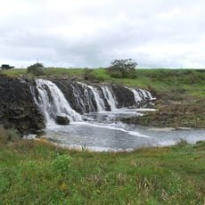
Hopkins Falls
17.1 km
Former Temperance Hall
22.2 km
Merrang Homestead
16.5 km
Glenormiston (Homestead and Former Agricultural College)
23.1 km
Ellerslie Bridge
4.9 km
Youl's Creek Bridge
21.5 km
Avenue of Honour
17.5 km
Chimney, Bluestone Mill
16.6 km
Quamby Bridge
21.5 km
Black Falls Lookout
14.7 km
Cudgee Wildlife Park
17.1 km
Terang Golf Club
19.3 km
Hopkins Falls Lookout
17.1 km
Scenic viewpoint
20.9 km
Hopkins River Lookout
22.9 km
Hopkins Falls Lookout
17.1 km
Scenic viewpoint
17 km
Mortlake Golf Club
15.8 km
Terang War Memorial
20.1 km
Hexham War Memorial
22 km
Mortlake War Memorial
15.8 km
Great European War Memorial
18.3 km
Boer War Memorial
15.6 km
Hopkins Falls
17.1 km
Black Falls
14.8 kmReviews
Visited this place? Tap the stars to rate it and share your experience / photos with the community! Try now! You can cancel it anytime.
Discover hidden gems everywhere you go!
From secret cafés to breathtaking viewpoints, skip the crowded tourist spots and find places that match your style. Our app makes it easy with voice search, smart filtering, route optimization, and insider tips from travelers worldwide. Download now for the complete mobile experience.

A unique approach to discovering new places❞
— Le Figaro
All the places worth exploring❞
— France Info
A tailor-made excursion in just a few clicks❞
— 20 Minutes