Tyneside Golf Club
Location: Gateshead
Address: Westfield Lane
Phone: +441914132742
Website: http://tynesidegolfclub.co.uk
GPS coordinates: 54.97806,-1.77740
Latest update: December 5, 2025 09:21
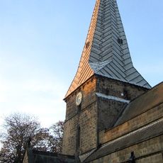
Church of Holy Cross
754 m
Fenwick Tomb About 24 Metres South And 6 Metres East Of Church Of Holy Cross
777 m
Ryton Library
1.1 km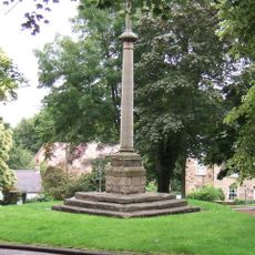
Ryton War Memorial
865 m
Gate Piers To East Of Ryton Rectory
832 m
The Grove (Church Army Home For The Elderly)
1 km
Barn, Stables, Shelters, Implement Shed And Pig Sties To South Of Town Farmhouse
910 m
Fountain In Wall Of Barmoor Lane
686 m
2, Whitewell Lane
1.1 km
The Nook
766 m
Town Farmhouse And Farm Buildings Attached
896 m
Stack Yard Wall To South Of Town Farm Building
905 m
Chancer Tomb Above 24 Metres South Of Church Of Holy Cross
774 m
The Rectory
780 m
Ryton village cross 160m south east of church
856 m
4, Barmoor Lane
791 m
Motte, 50m north of Holycross Church, Ryton
760 m
6, Village West
778 m
Tidestone Approx 200 Yards South-West Of Heddon Farmhouse
607 m
Clara Vale War Memorial
922 m
Fountain In Wall Of Barmoor Lane
671 m
Cross House
827 m
Dean Hall House The Glen Thorpe House
744 m
Pinfold
697 m
4 Lamp Posts About 2 Metres South, 17 Metres East And 72 Metres East Of Porch Of Church Of Holy Cross And 2 Metres North Of Church Of Church Gate
820 m
White House
873 m
Ryton Golf Club
772 m
Scenic viewpoint
1.1 kmVisited this place? Tap the stars to rate it and share your experience / photos with the community! Try now! You can cancel it anytime.
Discover hidden gems everywhere you go!
From secret cafés to breathtaking viewpoints, skip the crowded tourist spots and find places that match your style. Our app makes it easy with voice search, smart filtering, route optimization, and insider tips from travelers worldwide. Download now for the complete mobile experience.

A unique approach to discovering new places❞
— Le Figaro
All the places worth exploring❞
— France Info
A tailor-made excursion in just a few clicks❞
— 20 Minutes