山茶花高原ピクニックパーク・ハーブ園
Location: 太良町
Website: https://sazanka-kougen.com
GPS coordinates: 32.96893,130.14280
Latest update: March 12, 2025 20:28
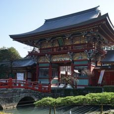
Yūtoku Inari Shrine
12.1 km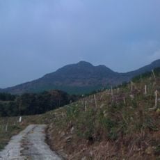
Mount Kyogatake
6.5 km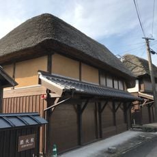
Hamashozumachi Hamakanayamachi
13.8 km
Hamanakamachi Hachihongishuku
14 km
岩崎社
12.1 km
命婦社
12.2 km
Floating Torii of Oouo Shrine
7.6 km
Stele, memorial
7.8 km
Scenic viewpoint
10.6 km
水害復興記念碑
10.8 km
仏の谷公園
11.7 km
若宮社
12.1 km
千年樫の木
6.8 km
慰霊塔
5.7 km
Scenic viewpoint
12.2 km
石壁社
12.2 km
岩本社
12.2 km
Memorial
7 km
Scenic viewpoint
12.2 km
災害復興之碑
12.6 km
七八災害復興之碑
12.9 km
おしまさん像
13.1 km
Scenic viewpoint
13.5 km
Memorial
5.2 km
Village houses with reed roof
13.8 km
18th to early 20th century houses
14 km
Memorial
2.2 km
大村湾カントリー倶楽部
14.3 kmReviews
Visited this place? Tap the stars to rate it and share your experience / photos with the community! Try now! You can cancel it anytime.
Discover hidden gems everywhere you go!
From secret cafés to breathtaking viewpoints, skip the crowded tourist spots and find places that match your style. Our app makes it easy with voice search, smart filtering, route optimization, and insider tips from travelers worldwide. Download now for the complete mobile experience.

A unique approach to discovering new places❞
— Le Figaro
All the places worth exploring❞
— France Info
A tailor-made excursion in just a few clicks❞
— 20 Minutes