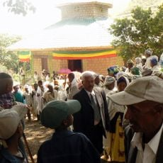
Debrebirhan Eid Street
Location: North Shewa (Amhara Region)
GPS coordinates: 9.67260,39.52685
Latest update: November 3, 2025 01:03
Yelet Giorgis Church, Bulga
57.8 km
Menelik II Military Camp
55.6 km
Menelik II's Palace
25.6 km
Gobble Farming
62.5 km
Mohammed Haji Baba
47.2 km
View point
54.3 km
Zebir Gebreal church
55.7 km
ፃድቃኔ ማርያምና ገዳም
33.4 km
ደብረ ብርሀን Debre Brihan
545 m
Waterfall
16.5 km
Scenic viewpoint
28 km
Bulga View
56.3 km
Scenic viewpoint
53.1 km
Kebele 03 Adebabay
315 m
Scenic viewpoint
27.9 km
Scenic viewpoint
55.4 km
Scenic viewpoint
48.7 km
Scenic viewpoint
49.2 km
Scenic viewpoint
50.4 km
Scenic viewpoint
52 km
Scenic viewpoint
40.6 km
Scenic viewpoint
49.5 km
Scenic viewpoint
47.7 km
Scenic viewpoint
51.4 km
Scenic viewpoint
50.4 km
Scenic viewpoint
53.4 km
Scenic viewpoint
27.3 km
Mount Debre Sina 3248 MASL
28 kmReviews
Visited this place? Tap the stars to rate it and share your experience / photos with the community! Try now! You can cancel it anytime.
Discover hidden gems everywhere you go!
From secret cafés to breathtaking viewpoints, skip the crowded tourist spots and find places that match your style. Our app makes it easy with voice search, smart filtering, route optimization, and insider tips from travelers worldwide. Download now for the complete mobile experience.

A unique approach to discovering new places❞
— Le Figaro
All the places worth exploring❞
— France Info
A tailor-made excursion in just a few clicks❞
— 20 Minutes