End of asphalt
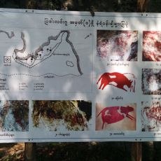
Padah-Lin Caves
33.6 km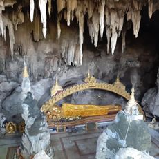
Dat Taw Taung Cave
31.8 km
City Clock Tower
36 km
မိုင်းမောမြို့ဟောင်းအဆောက်အအုံဟောင်း
19.8 km
ခြံကြီးကျောင်းလမ်း
21.9 km
Swim spot with shade and stands
11.3 km
Pan Thi Da
28 km
Dee Dote 5 floor
35.9 km
Badah-lin Cave
33.5 km
ဆင်ခေါင်းတောင် view point
9.6 km
မန်ကျည်းတော
15.4 km
Lay Myat Nar Theatre(လေးမျက်နှာဇာတ်ရုံ)
35.8 km
လြန္ေကာင္း
34 km
Scenic viewpoint
7.6 km
Biggest Latpan Tree
17.5 km
Pyadda Lin Cave
29.1 km
ပျူခေတ်အဆောက်အအုံဟောင်း
19.3 km
မြင်စိုင်းမြို့ဟောင်း
30.8 km
မိုင်းမော(ပင်လယ်)မြို့ဟောင်း
20.9 km
နန်တော်ရာဘုရား
20.9 km
Lal Pyin Thar monastics Schools
35.9 km
ပျူခေတ်အဆောက်အအုံဟောင်း
19.3 km
ပျူခေတ်အဆောက်အအုံဟောင်း
21.2 km
မိုင်းမောမြို့ဟောင်းအဆောက်အအုံ
20.9 km
Entrance road to Dee Doke waterfall (little way at the bridge, many Burmese signs)
35.1 km
Dee Dote Waterfall
36 km
Waterfall
8.4 km
Waterfall
8.4 kmReviews
Visited this place? Tap the stars to rate it and share your experience / photos with the community! Try now! You can cancel it anytime.
Discover hidden gems everywhere you go!
From secret cafés to breathtaking viewpoints, skip the crowded tourist spots and find places that match your style. Our app makes it easy with voice search, smart filtering, route optimization, and insider tips from travelers worldwide. Download now for the complete mobile experience.

A unique approach to discovering new places❞
— Le Figaro
All the places worth exploring❞
— France Info
A tailor-made excursion in just a few clicks❞
— 20 Minutes