
Pine Tree line
Location: Don Salvador Benedicto
GPS coordinates: 10.56243,123.20211
Latest update: November 14, 2025 17:10
Northern Negros Natural Park
8.1 km
Graceland
12 km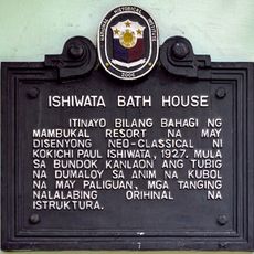
Ishiwata Bath House historical marker
12.2 km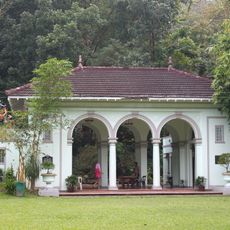
Ishiwata Bath House
12.2 km
Malatan-og Viewing Deck
4.3 km
Chocolate Hills Viewing Point
10.8 km
SharkWave
12.6 km
Zero-One Hanging Bridge
3.2 km
Saint Padre Pio's Garden
400 m
WavePool
12.6 km
Foam Fun
12.6 km
Lion International
462 m
Malantan-og Viewdeck
6.9 km
Negros Chocolate Hills Viewing Point
10.3 km
ROCK
9.7 km
Campuestuhan Horse Backriding
12.6 km
Ridge Top Entrance
10.9 km
Swamp End
10.9 km
Swamp Entrance
10.9 km
Jomax's Peak
3.9 km
Via Crucis (Way of the Cross) Padre Pio
395 m
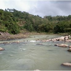
Falls
12.1 km
7th Falls
12.2 km
First Fall
12 km
Malatan-og Falls
4.5 km
Second Fall
12 km
Waterfall
10.5 km
Kawa Falls
5.6 kmReviews
Visited this place? Tap the stars to rate it and share your experience / photos with the community! Try now! You can cancel it anytime.
Discover hidden gems everywhere you go!
From secret cafés to breathtaking viewpoints, skip the crowded tourist spots and find places that match your style. Our app makes it easy with voice search, smart filtering, route optimization, and insider tips from travelers worldwide. Download now for the complete mobile experience.

A unique approach to discovering new places❞
— Le Figaro
All the places worth exploring❞
— France Info
A tailor-made excursion in just a few clicks❞
— 20 Minutes