
Дорога Старого Чуйского тракта
Location: Ининское сельское поселение
GPS coordinates: 50.39048,86.66262
Latest update: November 13, 2025 17:27
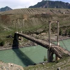
Inya Bridge
7.9 km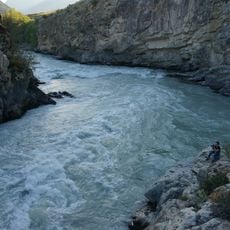
Gorizont Rapid
5.2 km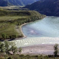
Chuya and Katun Rivers Confluence
928 m
Turbinny Rapid
5.9 km
Stèles d'Inia
5.6 km
Parc national de Tchouï-Oozy
1.2 km
Большой каменный курган
5.8 km
Курганы
3.5 km
Порог Турбинный
5.9 km
Порог Горизонт
5.2 km
Песчаные столбы
7.6 km
Петроглифы Чуй-Оозы
3 km
Девушка
3.2 km
Архар
3.2 km
Ирбис
3.2 km
Буйвол
3.2 km
Верблюд
3.2 km
Колесница
3.2 km
Слияние Чуи и Катуни
965 m
Слияние Чуи и Катуни
1 km
Scenic viewpoint
2.5 km
Ининский мост
7.7 km
Обзорная площадка на порог Турбинный
6.1 km
Обзорная площадка
2.2 km
Вид на мост
7.7 km
В. И. Ленину
7.7 km
Братская могила 83 красноармейцев
7 km
Memorial, war memorial
7.1 kmReviews
Visited this place? Tap the stars to rate it and share your experience / photos with the community! Try now! You can cancel it anytime.
Discover hidden gems everywhere you go!
From secret cafés to breathtaking viewpoints, skip the crowded tourist spots and find places that match your style. Our app makes it easy with voice search, smart filtering, route optimization, and insider tips from travelers worldwide. Download now for the complete mobile experience.

A unique approach to discovering new places❞
— Le Figaro
All the places worth exploring❞
— France Info
A tailor-made excursion in just a few clicks❞
— 20 Minutes