Wat Tham Dok Kam
Location: จังหวัดเชียงใหม่
GPS coordinates: 19.34369,99.16345
Latest update: November 14, 2025 19:40

La Ciudadela
9.7 km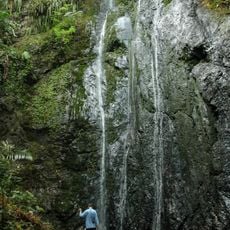
Pha Daeng National Park
20.8 km
Wat Mae Pang
14.8 km
Si Lanna National Park
10.2 km
Wat Pa Thara Phirom
18.7 km
Mae Ngat Sombunchon Reservoir
20.7 km
Ang Kep Nam Mae Phaeng
10.9 km
Wat Ton Kok
6.7 km
Scenic viewpoint
11.9 km
Scenic viewpoint
15.8 km
Wat Pa Bunnak
19.2 km
Buddha
21.2 km
Scenic viewpoint
21.2 km
จุดชมวิวดอยม่อนล้าน
17.4 km
Sairung Waterfall
19.7 km
Scenic viewpoint
16.9 km
Scenic viewpoint
15.8 km
Buddhist Temples
20.7 km
Scenic viewpoint
12.3 km
Scenic viewpoint
8.4 km
Mon Lan Viewpoint
17.8 km
Scenic viewpoint
16.6 km
Scenic viewpoint
17.1 km
Scenic viewpoint
9.6 km
ดอยม่อนล้าน
21.2 km
Scenic viewpoint
21.2 km
Scenic viewpoint
19 km
Wayside shrine
21 kmReviews
Visited this place? Tap the stars to rate it and share your experience / photos with the community! Try now! You can cancel it anytime.
Discover hidden gems everywhere you go!
From secret cafés to breathtaking viewpoints, skip the crowded tourist spots and find places that match your style. Our app makes it easy with voice search, smart filtering, route optimization, and insider tips from travelers worldwide. Download now for the complete mobile experience.

A unique approach to discovering new places❞
— Le Figaro
All the places worth exploring❞
— France Info
A tailor-made excursion in just a few clicks❞
— 20 Minutes