Курган
Location: Лядскі сельскі Савет
GPS coordinates: 53.73247,28.70391
Latest update: October 11, 2024 02:02
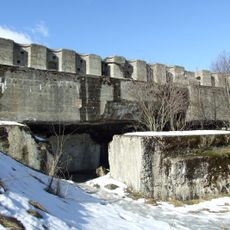
Hrodna Fortress
9.9 km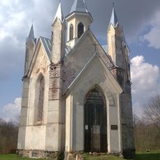
Church of the Corpus Christi, Bahuševičy
7.9 km
Work of art
8.2 km
Work of art
8.2 km
Спаленай вёсцы Буда
5 km
Курган
5.7 km
Царква (разваліны)
6.5 km
Капліца могілкавая
6.5 km
Курган
6.7 km
Помнік
7.9 km
Помнік
3.8 km
Kościół Bożego Ciała
7.9 km
Помнік другой сусветнай
8 km
Помнік
3.6 km
Work of art
8.2 km
Помнік
4.1 km
380 Габрэяў
8.3 km
Вечная памяць воінам і партызанам
8.3 km
Помнік
8.3 km
Жыхарам вёскі
8.7 km
Прысядзібны парк
9.8 km
Гарадзішча
439 m
Помнік
11 km
Помнік
11.1 km
Scenic viewpoint
12.1 km
Monument
12.9 km
Гарадзішча
13 km
Брацкая магіла 48 воінаў загінуўшых у ліпені 1944 г.
13.5 kmReviews
Visited this place? Tap the stars to rate it and share your experience / photos with the community! Try now! You can cancel it anytime.
Discover hidden gems everywhere you go!
From secret cafés to breathtaking viewpoints, skip the crowded tourist spots and find places that match your style. Our app makes it easy with voice search, smart filtering, route optimization, and insider tips from travelers worldwide. Download now for the complete mobile experience.

A unique approach to discovering new places❞
— Le Figaro
All the places worth exploring❞
— France Info
A tailor-made excursion in just a few clicks❞
— 20 Minutes