Blindé M75 Full Track
Location: Orbais
Location: Perwez
GPS coordinates: 50.65366,4.77635
Latest update: October 11, 2024 02:20

Moulin Gustot
3.3 km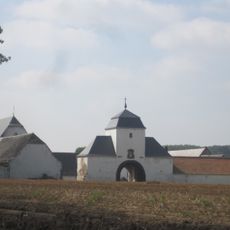
Ferme de Mellemont
1.7 km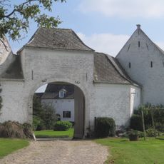
Ferme du Mont
1.7 km
Église Saint-Trond de Thorembais-Saint-Trond
2.1 km
Scenic viewpoint
2.3 km
Chapelle Notre-Dame des Affligés
1.8 km
Catholic church building, wayside shrine, Christianity
2.8 km
Memorial aux morts
2.1 km
Canon britannique
2.1 km
Memorial, war memorial
2.1 km
Chapelle Sainte-Thérèse
465 m
Saint Donat
2.2 km
Monument Shawn B24
2.2 km
Memorial
274 m
La Grosse Borne
2.6 km
Chapelle Notre Dame de Hal
2.8 km
Louis Reyntens
1.1 km
Wayside shrine, Christianity, Catholic church building
2.9 km
Catholic church building, wayside shrine, Christianity
3.1 km
Wayside shrine, Christianity
3.1 km
Catholic church building, wayside shrine, Christianity
3.3 km
Chapelle du Dieu Aimant
3.3 km
Catholic church building, wayside shrine, Christianity
13 m
Mémorial aux soldats durant la 1ère guerre
3.3 km
Potale Saint-Pierre
3.3 km
Mémorial Alphonse Robert
3.3 km
Catholic church building, wayside shrine, Christianity
3.4 km
Catholic church building, wayside shrine, Christianity
3.4 kmReviews
Visited this place? Tap the stars to rate it and share your experience / photos with the community! Try now! You can cancel it anytime.
Discover hidden gems everywhere you go!
From secret cafés to breathtaking viewpoints, skip the crowded tourist spots and find places that match your style. Our app makes it easy with voice search, smart filtering, route optimization, and insider tips from travelers worldwide. Download now for the complete mobile experience.

A unique approach to discovering new places❞
— Le Figaro
All the places worth exploring❞
— France Info
A tailor-made excursion in just a few clicks❞
— 20 Minutes