Vieux Four à Pain
Location: La Rouxière
Location: Loireauxence
GPS coordinates: 47.44263,-1.06763
Latest update: October 11, 2024 03:04

Église Saint-Hermeland de La Rouxière
41 m
Église Saint-Hermeland de Saint-Herblon
4.4 km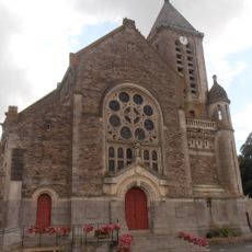
Église Saint-Martin de Belligné
4 km
Chapelle Saint-Michel-des-Bois de La Roche-Blanche
4.2 km
Wayside cross
1.2 km
Calvaire
3.5 km
Christianity, Catholic church building, wayside cross
298 m
Wayside cross
1.2 km
Wayside cross
1.4 km
Wayside cross
1.7 km
Ancienne Mine de Charbon
1.8 km
Wayside cross
2 km
Wayside cross, Christianity, Catholic church building
2.4 km
Christianity, Catholic church building, wayside cross
2.8 km
Wayside cross
3.1 km
Calvaire
3.2 km
Calvaire
3.2 km
Rue de l'Étang Corbin
872 m
Calvaire
4 km
Wayside cross
4 km
Calvaire
253 m
Wayside cross
4.1 km
Wayside cross
56 m
Memorial, commemorative plaque
4.2 km
Calvaire
55 m
Wayside cross
4.4 km
Wayside cross
4.4 km
Wayside cross
4.5 kmReviews
Visited this place? Tap the stars to rate it and share your experience / photos with the community! Try now! You can cancel it anytime.
Discover hidden gems everywhere you go!
From secret cafés to breathtaking viewpoints, skip the crowded tourist spots and find places that match your style. Our app makes it easy with voice search, smart filtering, route optimization, and insider tips from travelers worldwide. Download now for the complete mobile experience.

A unique approach to discovering new places❞
— Le Figaro
All the places worth exploring❞
— France Info
A tailor-made excursion in just a few clicks❞
— 20 Minutes