ساحل مخرمه
Location: محافظة جنوب الشرقية
GPS coordinates: 22.56968,59.53271
Latest update: November 12, 2025 11:54
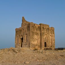
Ancient City of Qalhat
21.2 km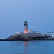
Sur lighthouse
720 m
"Tiger Rock"
18.4 km
Dhau
962 m
Khor al Batar Bridge
946 m
الساحل
408 m
بنو غزال
26.8 km
المضيف صور
1.3 km
DHAU
961 m
Display of waterfall
978 m
Dhow Yards
979 m
Beach : camping ok
26.2 km
Neena Corniche
189 m
Ayjah / Sur
1.1 km
Scenic viewpoint
716 m
Scenic viewpoint
895 m
شياع العوامر
9.1 km
Dhow factory
980 m
Scenic viewpoint
12.3 km
قلعة بلاد صور
4.9 km
Sunaysilah Castle
3.1 km
منارة العيجة
843 m
قلعة الجناه
5.9 km
Ruins
20.9 km
Ruins
20.9 km
سوق صور التراثي
637 m
Ruins
21.5 km
دوار بلاد صور
5.8 kmReviews
Visited this place? Tap the stars to rate it and share your experience / photos with the community! Try now! You can cancel it anytime.
Discover hidden gems everywhere you go!
From secret cafés to breathtaking viewpoints, skip the crowded tourist spots and find places that match your style. Our app makes it easy with voice search, smart filtering, route optimization, and insider tips from travelers worldwide. Download now for the complete mobile experience.

A unique approach to discovering new places❞
— Le Figaro
All the places worth exploring❞
— France Info
A tailor-made excursion in just a few clicks❞
— 20 Minutes