Город Сим
Location: Симское городское поселение
GPS coordinates: 54.99999,57.65828
Latest update: November 14, 2025 06:08
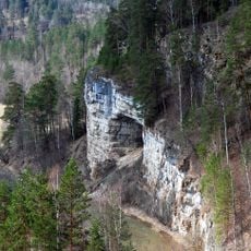
Ignateva Cave
13.7 km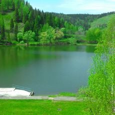
Simsky Pond
2.4 km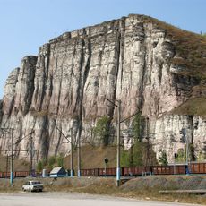
Geological outcrops of argillites
10.6 km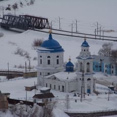
Church of the Entry of the Theotokos into the Temple (Minyar)
10.2 km
Церковь (Сим)
2.7 km
Железоделательный завод (Миньяр)
10.1 km
Водонапорная башня с фотографии Прокудина-Горского
7.1 km
В. И. Ленину
2.3 km
Пляж
3.2 km
Сим
4.6 km
Каменный мост
8.2 km
Scenic viewpoint
3.5 km
Scenic viewpoint
19.5 km
Scenic viewpoint
19.7 km
БМП
2.4 km
Основателям Миньяра
10.4 km
В. И. Ленину
10.6 km
Понор Сима
14.6 km
И. В. Курчатову
2.7 km
М. В. Гузакову
2.3 km
Красногвардейцам и партизанам
10.4 km
40 лет Победы
10.4 km
БМП-1
10.4 km
Миниахметов В.Р.
10.6 km
БМП-1
10.4 km
Пограничные войска
10.4 km
ВМФ
10.4 km
ВДВ
10.4 kmReviews
Visited this place? Tap the stars to rate it and share your experience / photos with the community! Try now! You can cancel it anytime.
Discover hidden gems everywhere you go!
From secret cafés to breathtaking viewpoints, skip the crowded tourist spots and find places that match your style. Our app makes it easy with voice search, smart filtering, route optimization, and insider tips from travelers worldwide. Download now for the complete mobile experience.

A unique approach to discovering new places❞
— Le Figaro
All the places worth exploring❞
— France Info
A tailor-made excursion in just a few clicks❞
— 20 Minutes