Tehokowhitu-A-Tu
Location: Rotorua Lakes District
GPS coordinates: -38.16169,176.25665
Latest update: December 4, 2025 13:48
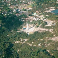
Whakarewarewa
81 m
Pohutu Geyser
303 m
Rauru-me-Nuku-te-apiapi
123 m
Kusabs House
239 m
Te Awa i Manukau
167 m
Geyser viewpoint
220 m
Scenic viewpoint
319 m
Mud Pools
318 m
Te Puia Thermal Park
612 m
Work of art, sculpture
575 m
Work of art, statue
98 m
Work of art, sculpture
79 m
Scenic viewpoint
321 m
Upper Whaka Outlook
645 m
Whakarewarewa Living village
73 m
Lower Whaka Outlook
592 m
Thermal area
485 m
Scenic viewpoint
274 m
Scenic viewpoint
134 m
Scenic viewpoint
32 m
Scenic viewpoint
306 m
Scenic viewpoint
278 m
Scenic viewpoint
224 m
Scenic viewpoint
229 m
Scenic viewpoint
201 m
Scenic viewpoint
404 m
Scenic viewpoint
172 m
Archaeological site
38 mVisited this place? Tap the stars to rate it and share your experience / photos with the community! Try now! You can cancel it anytime.
Discover hidden gems everywhere you go!
From secret cafés to breathtaking viewpoints, skip the crowded tourist spots and find places that match your style. Our app makes it easy with voice search, smart filtering, route optimization, and insider tips from travelers worldwide. Download now for the complete mobile experience.

A unique approach to discovering new places❞
— Le Figaro
All the places worth exploring❞
— France Info
A tailor-made excursion in just a few clicks❞
— 20 Minutes