בולבוסי קידר
Location: מועצה אזורית חבל אילות
GPS coordinates: 29.89494,34.83341
Latest update: November 11, 2025 20:03

Ẕuqé ‘Uvda
9.5 km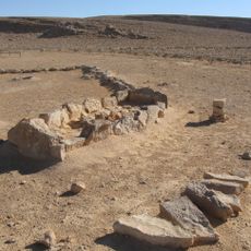
Leopards Temple
14.8 km
Har Berekh
13.8 km
Har Seguv
15.2 km
Nahal Issaron
12.7 km
Zuqe Timna`
14.6 km
תצפית מדהימה על פארק תמנע
14.4 km
Mt. Berech viewpoint
13.9 km
חיים אשכנזי
4.4 km
מכרות
14.7 km
The Arches
14.9 km
אמוניטים
14.1 km
Scenic viewpoint
14.8 km
The Chariots
15.2 km
איתי אייל ושני שחם
14.8 km
Scenic viewpoint
14.8 km
Scenic viewpoint
14.8 km
Scenic viewpoint
13.6 km
Ancient Mines
15.1 km
הצלחות
15 km
פירי כריה
14.8 km
עפיפון מדבר - מצפה סיירים
3.5 km
Archaeological site
14.6 km
שדה אברהם
8.2 km
Waterfall
13.9 km
Waterfall
14.7 km
Waterfall
13.6 km
Waterfall
14.6 kmReviews
Visited this place? Tap the stars to rate it and share your experience / photos with the community! Try now! You can cancel it anytime.
Discover hidden gems everywhere you go!
From secret cafés to breathtaking viewpoints, skip the crowded tourist spots and find places that match your style. Our app makes it easy with voice search, smart filtering, route optimization, and insider tips from travelers worldwide. Download now for the complete mobile experience.

A unique approach to discovering new places❞
— Le Figaro
All the places worth exploring❞
— France Info
A tailor-made excursion in just a few clicks❞
— 20 Minutes