
תצפית על נקודת מעבר מתחת לכביש. מעבר לפלסטינאים מתחת לגדר ההפרדה.
תצפית על נקודת מעבר מתחת לכביש. מעבר לפלסטינאים מתחת לגדר ההפרדה.
Location: שטח C
Website: https://i.imgur.com/Y94tqJQ.jpg
GPS coordinates: 31.83847,35.18834
Latest update: October 24, 2025 18:53
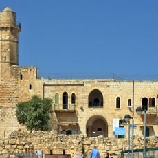
Tomb of Samuel
1 km
Atarot
3 km
Al Judayrah
2.1 km
Al Jīb
1.6 km
מערת קבורה
1.4 km
אבן כתישה
1.4 km
תנור
919 m
גת
961 m
מערת קבורה
971 m
Scenic viewpoint
980 m
נבי סמואל
984 m
מערת קבורה
544 m
הבונקר הגדול
1.1 km
מתקנים חצובים
503 m
מערת קבורה
1.4 km
מוצב ירדני
1.4 km
גת
1.4 km
Ruins
837 m
ח'ירבת א-שוומר
1.4 km
מערת קבורה
435 m
גת
1.6 km
גת
417 m
Scenic viewpoint
2.4 km
גת
2.5 km
כבשן סיד
2.6 km
חורבת תליליה
3 km
מערת קבורה
125 m
Ruins
3.1 kmReviews
Visited this place? Tap the stars to rate it and share your experience / photos with the community! Try now! You can cancel it anytime.
Discover hidden gems everywhere you go!
From secret cafés to breathtaking viewpoints, skip the crowded tourist spots and find places that match your style. Our app makes it easy with voice search, smart filtering, route optimization, and insider tips from travelers worldwide. Download now for the complete mobile experience.

A unique approach to discovering new places❞
— Le Figaro
All the places worth exploring❞
— France Info
A tailor-made excursion in just a few clicks❞
— 20 Minutes