
מצפור מזרחי הר כביר
Location: מועצה אזורית שומרון
GPS coordinates: 32.24255,35.32856
Latest update: November 12, 2025 18:23
Altar on Mount Ebal
3.9 km
Benyo Lookout
4.9 km
Wadi Al-Badan
2.1 km
Al Quran
2.4 km
‘Irāq at Tā'ih
5.2 km
Al Bādhān
1.8 km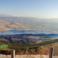
מצפה לונץ
43 m
מצפה אילן
1.6 km
Maghārat al Bārid
4.6 km
Maghārat ‘Uşfūrah
4.8 km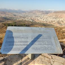
מצפור דרומי הר כביר
225 m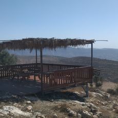
מצפה רנה
2.8 km
מצפה הר עיבל
145 m
منتزهات الباذان
2.1 km
מצפה אביתר
3.6 km
الصالة الألمانية
4.1 km
مفرق جسر الملاكي
3.2 km
دوار بئر مياه الفارعة/ نابلس
3.1 km
فيلا
4.9 km
Beauty Kingdom Company Ltd.
3.8 km
ع الشورطي الجديدة
3.8 km
معسكر سميط
3.8 km
תצפית מזבח יהושע
4.3 km
Yaseed Junction
4.8 km
Benyo Lookout
4.9 km
El 'Unuq
4.1 km
عمارة ابو علاء الشيخ
4.1 km
Memorial
4.2 kmReviews
Visited this place? Tap the stars to rate it and share your experience / photos with the community! Try now! You can cancel it anytime.
Discover hidden gems everywhere you go!
From secret cafés to breathtaking viewpoints, skip the crowded tourist spots and find places that match your style. Our app makes it easy with voice search, smart filtering, route optimization, and insider tips from travelers worldwide. Download now for the complete mobile experience.

A unique approach to discovering new places❞
— Le Figaro
All the places worth exploring❞
— France Info
A tailor-made excursion in just a few clicks❞
— 20 Minutes