
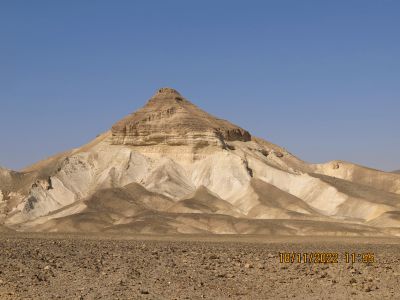
גבעת בוהר
Location: מועצה אזורית הערבה התיכונה
GPS coordinates: 30.31809,35.12104
Latest update: October 24, 2025 18:55
Moa (Nabataeans city)
25.2 km
Mt. Kipa view point
13.5 km
תצפית חדוד
9.3 km
Scenic viewpoint
14.1 km
Eshet Hadasa Reservoir
6.9 km
Paran Cliffs Viewpoint
14.3 km
Scenic viewpoint
18.9 km
ביצת הפתעה (עצמון)
21.2 km
Nahal Wardit
10.2 km
סלע השטן
18.1 km
בולדרים
13.3 km
Notza Ridge
18.8 km
סלע עם גבישי קוורץ
18.1 km
פרסת עשוש (מצוק עשוש)
18.8 km
זקיף סלע
22.9 km
Scenic viewpoint
18.7 km
The turtle site
10.3 km
Scenic viewpoint
1.8 km
פטריית פז ירום
21.8 km
מצפור פארן
6.4 km
Israel Trail Library
25.1 km
Scenery Sofa
18.3 km
Israel Trail library
7.6 km
Tsihor palace
9.7 km
Scenic viewpoint
8 km
Scenic viewpoint
18.1 km
Scenic viewpoint
19.4 km
Bench, scenic viewpoint
19.8 kmReviews
Visited this place? Tap the stars to rate it and share your experience / photos with the community! Try now! You can cancel it anytime.
Discover hidden gems everywhere you go!
From secret cafés to breathtaking viewpoints, skip the crowded tourist spots and find places that match your style. Our app makes it easy with voice search, smart filtering, route optimization, and insider tips from travelers worldwide. Download now for the complete mobile experience.

A unique approach to discovering new places❞
— Le Figaro
All the places worth exploring❞
— France Info
A tailor-made excursion in just a few clicks❞
— 20 Minutes