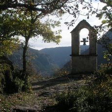
Catholic church building, wayside cross
Location: Saint-Pierre-des-Tripiers
Inception: January 1, 1879
GPS coordinates: 44.22615,3.27274
Latest update: November 30, 2025 15:12
Roc Saint-Gervais
2.5 km
Église Saint-Pierre de Saint-Pierre-des-Tripiers
26 m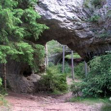
Arcs de Saint-Pierre
1.6 km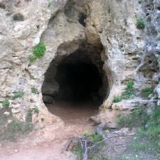
Grotte de l'Homme mort
1.2 km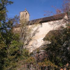
Chapelle Saint-Gervais-et-Saint-Protais des Douzes
2.5 km
Aven de Baume Fromagère
1.1 km
Scenic viewpoint
1.3 km
Scenic viewpoint
2.3 km
Scenic viewpoint
2.3 km
Ruins
2.2 km
Wayside cross
175 m
Arcs de Saint-Pierre et ruines protohistoriques
1.6 km
Catholic church building, wayside cross
231 m
Catholic church building, wayside cross
2.2 km
Statue, Work of art
2.5 km
Ruins
2.4 km
Ruins
2.4 km
Ancien village de résiniers
1.6 km
Ruins
2.4 km
Wayside cross
96 m
Wayside cross
793 m
Wayside cross
2.9 km
Ancien four à chaux
2.5 km
Ancien four à chaux
2.2 km
Ruins
2.8 km
Ruins
2.7 km
Dolmen
2.3 km
Ruins
2.5 kmVisited this place? Tap the stars to rate it and share your experience / photos with the community! Try now! You can cancel it anytime.
Discover hidden gems everywhere you go!
From secret cafés to breathtaking viewpoints, skip the crowded tourist spots and find places that match your style. Our app makes it easy with voice search, smart filtering, route optimization, and insider tips from travelers worldwide. Download now for the complete mobile experience.

A unique approach to discovering new places❞
— Le Figaro
All the places worth exploring❞
— France Info
A tailor-made excursion in just a few clicks❞
— 20 Minutes