High water mark
Location: Aubais
Inscription: Repère du crue Vidourle 2002
GPS coordinates: 43.73750,4.14311
Latest update: November 6, 2025 18:56
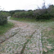
Via Domitia
2.4 km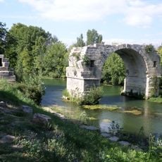
Pont Ambroix
2.4 km
Château d'Aubais
1.8 km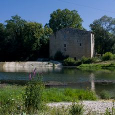
Moulin de Carrière
18 m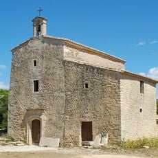
Chapelle Saint-Nazaire-de-Marissargues
1.7 km
Plan des Théâtres
1.8 km
Église Notre-Dame-et-Saints-Nazaire-et-Celse d'Aubais
1.9 km
Église Saint-Géraud-d'Aurillac de Villetelle
463 m
Temple d'Aubais
2 km
Scenic viewpoint
1.6 km
Scenic viewpoint
1.7 km
La Roque de Saint-Sériès
1.6 km
Scenic viewpoint
1.9 km
Catholic church building, wayside cross
1.8 km
Wayside cross
2 km
Wayside cross
1.7 km
Plaque funéraire Arthur Mabelly
1.2 km
Commemorative plaque, memorial
1.9 km
Catholic church building, wayside cross
1.9 km
Wayside cross
1.1 km
Wayside cross
1.8 km
Monument aux Morts
2 km
Le Petit Théâtre de Nathalie
779 m
Catholic church building, wayside cross
2.1 km
Croix d'Alexis
2.3 km
Catholic church building, wayside cross
585 m
Wayside cross, Catholic church building
421 m
Espace René Cavallier
2.5 kmReviews
Visited this place? Tap the stars to rate it and share your experience / photos with the community! Try now! You can cancel it anytime.
Discover hidden gems everywhere you go!
From secret cafés to breathtaking viewpoints, skip the crowded tourist spots and find places that match your style. Our app makes it easy with voice search, smart filtering, route optimization, and insider tips from travelers worldwide. Download now for the complete mobile experience.

A unique approach to discovering new places❞
— Le Figaro
All the places worth exploring❞
— France Info
A tailor-made excursion in just a few clicks❞
— 20 Minutes