High water mark
Location: Bourg-Saint-Andéol
Inscription: RHÔNE 1er NOVbre 1896
Made from material: metal
GPS coordinates: 44.35990,4.64638
Latest update: November 6, 2025 18:56
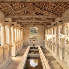
Lavoir de la Tourne
1.1 km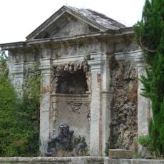
Bassin de Neptune
726 m
Grandes Fontaines
1.1 km
Scenic viewpoint
978 m
Work of art
1.1 km
Work of art
1.1 km
Calvaire
894 m
Work of art, statue
1 km
Work of art, statue
1 km
Work of art
1.1 km
E.Feschet
1.1 km
Work of art
1.1 km
Père Chiron
1.1 km
Madier De Montjau
844 m
High water mark
763 m
Work of art
1.1 km
High water mark
0 m
Wayside shrine
961 m
Work of art
1.1 km
Pierre Tondini
1.1 km
Work of art
1.1 km
Work of art
1.1 km
C. Bernheim
1.2 km
Work of art
1.2 km
High water mark
1.2 km
Work of art, statue
1.2 km
High water mark
1.2 km
Work of art
1.2 kmReviews
Visited this place? Tap the stars to rate it and share your experience / photos with the community! Try now! You can cancel it anytime.
Discover hidden gems everywhere you go!
From secret cafés to breathtaking viewpoints, skip the crowded tourist spots and find places that match your style. Our app makes it easy with voice search, smart filtering, route optimization, and insider tips from travelers worldwide. Download now for the complete mobile experience.

A unique approach to discovering new places❞
— Le Figaro
All the places worth exploring❞
— France Info
A tailor-made excursion in just a few clicks❞
— 20 Minutes