Wayside shrine
Location: Kirchberg i.Wald
GPS coordinates: 48.89650,13.18472
Latest update: November 14, 2025 00:06
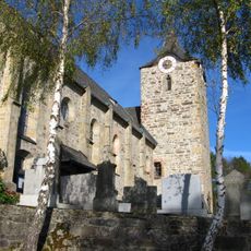
St. Gotthard (Kirchberg im Wald)
791 m
Cultural heritage D-2-7045-0019 in Kirchberg im Wald
787 m
Kapelle
3.1 km
Kapelle
2.3 km
Kapelle
2.6 km
Heiligenhäuschen
2.3 km
Wohnstallhaus
1.9 km
Kleines Waldlerhaus
3.1 km
Ehemaliges Mesnerhaus
761 m
Kapelle
2.6 km
Pfarrhof
645 m
Zugehöriger kleiner Traidkasten
2.7 km
Amthof-Brauerei
611 m
Friedhofsmauer Gotthardstraße 7 in Kirchberg im Wald
798 m
Nebengebäude Amthofplatz 4 in Kirchberg im Wald
663 m
Todtenau und Gföhretwiesen bei Zell
2.8 km
Kornspeicher
2.3 km
Scenic viewpoint
2.8 km
Scenic viewpoint
1.1 km
Wayside cross
1.9 km
Wayside cross
2.5 km
Wayside cross
2.7 km
Wayside cross
3.1 km
Wayside cross
3.1 km
Catholic church building, wayside cross, Christianity
813 m
Catholic church building, wayside cross, Christianity
1.9 km
Catholic church building, wayside cross, Christianity
822 m
Wayside cross
698 mReviews
Visited this place? Tap the stars to rate it and share your experience / photos with the community! Try now! You can cancel it anytime.
Discover hidden gems everywhere you go!
From secret cafés to breathtaking viewpoints, skip the crowded tourist spots and find places that match your style. Our app makes it easy with voice search, smart filtering, route optimization, and insider tips from travelers worldwide. Download now for the complete mobile experience.

A unique approach to discovering new places❞
— Le Figaro
All the places worth exploring❞
— France Info
A tailor-made excursion in just a few clicks❞
— 20 Minutes