Tank, war memorial
Location: Beffe
Location: Rendeux
GPS coordinates: 50.24496,5.52330
Latest update: November 19, 2025 22:36

Hermitage and chapel of Saint-Thibaut
3.9 km
Arboretum Robert Lenoir
1.3 km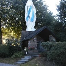
Virgin of Werpin
2.9 km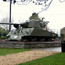
Tank memorial
1 m
Scenic viewpoint
3.9 km
Scenic viewpoint
1.1 km
Scenic viewpoint
1 km
Scenic viewpoint
1.1 km
Scenic viewpoint
1 km
Scenic viewpoint
3.3 km
Beverburchten
3.8 km
Auto
3.2 km
Chapel
2.6 km
Wayside cross
3.9 km
Wayside cross
3.8 km
American War Memorial
3.1 km
Chapelle des martyrs de 1944
3.5 km
Memorial stone Corporal Americain John Shields
4.1 km
Wayside cross
3.3 km
Wayside cross
4 km
Wayside cross
2.8 km
Motte de l'Ermitage Saint-Thibaut
3.9 km
Wayside shrine
3.8 km
Wayside cross
2.9 km
Croix Roger
2.9 km
Arrêt de l'avancée allemande 24 décembre 1944
3.5 km
Wayside cross
3.9 km
Croix Lili
3.6 kmVisited this place? Tap the stars to rate it and share your experience / photos with the community! Try now! You can cancel it anytime.
Discover hidden gems everywhere you go!
From secret cafés to breathtaking viewpoints, skip the crowded tourist spots and find places that match your style. Our app makes it easy with voice search, smart filtering, route optimization, and insider tips from travelers worldwide. Download now for the complete mobile experience.

A unique approach to discovering new places❞
— Le Figaro
All the places worth exploring❞
— France Info
A tailor-made excursion in just a few clicks❞
— 20 Minutes