
Erbaun, village in Kupang, East Nusa Tenggara Province, Indonesia
Location: Amarasi Barat
Elevation above the sea: 133 m
GPS coordinates: -10.32700,123.75600
Latest update: May 15, 2025 21:45

Mount Ramelau
247.7 km
Lewotolo
230.4 km
Mount Egon
233.9 km
Mount Sirung
207.5 km
Lewotobi
227.3 km
Iliboleng
227.6 km
Ashmore Reef Marine Park
225 km
Iliwerung
200.8 km
Lifau monument
139.9 km
Noefefan Bridge
138.7 km
Ave Maria church
199.2 km
Fort Santo António of Lifau
137.3 km
Bandeira Waterfall
241.4 km
Ilimuda
237.8 km
Sacred Heart Cathedral, Maliana
218.7 km
Marobo hot springs
226.9 km
Fort Balibo
206.9 km
Reduto do Conselheiro Jacinto Cândido
203.6 km
Fort Solor
220.2 km
Memorial do Dom Aleixo
243.1 km
Fort Concordia
27 km
Igreja de Nossa Senhora do Rosário, Pante Macassar
142.8 km
Nossa Senhora de Fátima
243 km
Quirilelo
252.1 km
Igreja da Imaculada Conceição Bobonaro
224.4 km
Kolam Airnona
24.7 km
Pantai Otan
44.1 km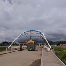
Mota'ain Bridge
201.1 kmReviews
Visited this place? Tap the stars to rate it and share your experience / photos with the community! Try now! You can cancel it anytime.
Discover hidden gems everywhere you go!
From secret cafés to breathtaking viewpoints, skip the crowded tourist spots and find places that match your style. Our app makes it easy with voice search, smart filtering, route optimization, and insider tips from travelers worldwide. Download now for the complete mobile experience.

A unique approach to discovering new places❞
— Le Figaro
All the places worth exploring❞
— France Info
A tailor-made excursion in just a few clicks❞
— 20 Minutes