Ampana Tete, district in Tojo Una Una Regency, Central Sulawesi Province, Indonesia
Location: Tojo Una Una
Elevation above the sea: 416 m
GPS coordinates: -1.07528,121.78111
Latest update: April 3, 2025 06:48

Lore Lindu National Park
184.3 km
Jesus Buntu Burake
309.2 km
Kete Kesu
298.7 km
Buntu Rantemario
323 km
Kepulauan Togean National Park
83.8 km
Al-Alam Kendari Mosque
334.1 km
Otanaha Fortress
226.6 km
Palopo Old Mosque
277 km
Palu IV Bridge
215 km
Bogani Nani Wartabone National Park
279 km
Floating Mosque of Palu
215.6 km
Colo
102.6 km
Pokekea Megalithic Site
187.5 km
Pantai Indah Modisi
340.3 km
Citraland Waterpark Kendari
335.7 km
Pantai Kampung Nelayan
213.2 km
Pantai Botutonuo
226.2 km
Rumah Katu Marine Park
140.5 km
Madale Beach
111.3 km
Sintuwu Maroso Square
119.6 km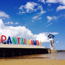
Pantai Nambo
338.7 km
Museum dan Monumen Pendaratan Pesawat Ampibi Catalina
226.6 km
Matua Water Boom
330 km
Baywalk Citraland Palu
213.3 km
Taman Nasional Hutan Mangrove
340.6 km
Siuri
161.2 km
Modisi Beach
339 km
Gereja KGPM Modisi
340.8 kmReviews
Visited this place? Tap the stars to rate it and share your experience / photos with the community! Try now! You can cancel it anytime.
Discover hidden gems everywhere you go!
From secret cafés to breathtaking viewpoints, skip the crowded tourist spots and find places that match your style. Our app makes it easy with voice search, smart filtering, route optimization, and insider tips from travelers worldwide. Download now for the complete mobile experience.

A unique approach to discovering new places❞
— Le Figaro
All the places worth exploring❞
— France Info
A tailor-made excursion in just a few clicks❞
— 20 Minutes