
Bangkurung, district in Banggai Laut Regency, Central Sulawesi Province, Indonesia
Location: Banggai Laut
Elevation above the sea: 4 m
GPS coordinates: -1.91385,123.08442
Latest update: May 17, 2025 03:31

Lore Lindu National Park
325.6 km
Kete Kesu
373 km
Kepulauan Togean National Park
212.9 km
Otanaha Fortress
274.3 km
Palopo Old Mosque
343.1 km
Bogani Nani Wartabone National Park
283.3 km
Colo
254.3 km
Rawa Aopa Watumohai National Park
300.9 km
Pokekea Megalithic Site
320.4 km
Pantai Indah Modisi
302.7 km
Citraland Waterpark Kendari
239.5 km
Pantai Kampung Nelayan
375.5 km
Pulo Cinta
277.6 km
Pantai Botutonuo
263 km
Rumah Katu Marine Park
288.6 km
Madale Beach
259.4 km
Sintuwu Maroso Square
265.6 km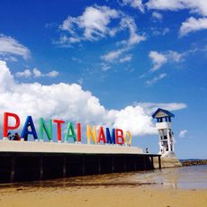
Pantai Nambo
238 km
Gereja GMIBM Efrata Modisi
303.2 km
Museum dan Monumen Pendaratan Pesawat Ampibi Catalina
275.4 km
Bulud Kanari
303.9 km
Baywalk Citraland Palu
376.4 km
Taman Nasional Hutan Mangrove
302.8 km
Siuri
284.6 km
Modisi Beach
301.9 km
Fort De Verwachting
322.5 km
Gereja GPDI Modisi
303.5 km
Gereja KGPM Modisi
303.1 kmReviews
Visited this place? Tap the stars to rate it and share your experience / photos with the community! Try now! You can cancel it anytime.
Discover hidden gems everywhere you go!
From secret cafés to breathtaking viewpoints, skip the crowded tourist spots and find places that match your style. Our app makes it easy with voice search, smart filtering, route optimization, and insider tips from travelers worldwide. Download now for the complete mobile experience.

A unique approach to discovering new places❞
— Le Figaro
All the places worth exploring❞
— France Info
A tailor-made excursion in just a few clicks❞
— 20 Minutes