Forêt rare du Mont-Gosford, aire protégée du Québec (Canada)
Location: Saint-Augustin-de-Woburn
Inception: 2009
GPS coordinates: 45.29639,-70.87889
Latest update: November 7, 2025 12:34

Kennebago Divide
9.6 km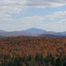
Snow Mountain
13.3 km
White Cap Mountain
8.2 km
Snow Mountain
14.7 km
Zec Louise-Gosford
20.7 km
Mount Pisgah
19 km
Mont Scotch Cap
16.2 km
Mount D'Urban
17.7 km
Mont-Gosford Ecological Reserve
480 m
Domaine des Appalaches
13.6 km
Parc de la Pointe-du-9e-Rang
14.2 km
Arnold Pond
12 km
Church of Our Lady
18.7 km
Sommet Valence
14 km
Barker Pond
10.3 km
Réserve naturelle du Marais-du-Lac-Mégantic
16.8 km
Twin Mountains
16.6 km
Massachusetts Bog
9.7 km
La tour à feu
21.2 km
Little Island Pond
7.9 km
Statue, Work of art
10.1 km
Scenic viewpoint, tower, Observation tower
1.1 km
Montagne de Marbre
11.3 km
Scenic viewpoint
18.9 km
Scenic viewpoint
16.2 km
Scenic viewpoint
16.2 km
Scenic viewpoint
16.1 km
Scenic viewpoint
16.1 kmReviews
Visited this place? Tap the stars to rate it and share your experience / photos with the community! Try now! You can cancel it anytime.
Discover hidden gems everywhere you go!
From secret cafés to breathtaking viewpoints, skip the crowded tourist spots and find places that match your style. Our app makes it easy with voice search, smart filtering, route optimization, and insider tips from travelers worldwide. Download now for the complete mobile experience.

A unique approach to discovering new places❞
— Le Figaro
All the places worth exploring❞
— France Info
A tailor-made excursion in just a few clicks❞
— 20 Minutes