
Zhůřská jedle, memorable tree in Klatovy District, Czech Republic
Location: Rejštejn
Height: 35 m
GPS coordinates: 49.09828,13.54833
Latest update: November 12, 2025 11:37
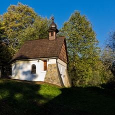
Chapel of Saint Barbara in Podlesí
1.7 km
Skupina lip na Podlesí
1.6 km
Leškovy lípy
2 km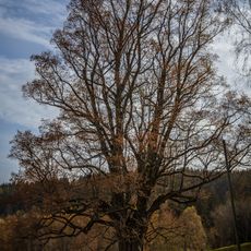
Lípa na Podlesí
1.8 km
Jilm pod Kozincem
1.9 km
Javor klen na Podlesí
1.4 km
Sklárna Stará Huť
1.1 km
Wayside cross
1.3 km
Wayside cross
1.8 km
Scenic viewpoint
1.1 km
Wayside cross
653 m
Wayside cross
1.1 km
Pomník obětem letecké nehody
445 m
Wayside cross
1.3 km
Scenic viewpoint
1.2 km
Wayside cross
1.1 km
Wayside cross
1.6 km
Wayside cross
1.7 km
Scenic viewpoint
695 m
Wayside cross
1.6 km
Ruins
1.5 km
Memorial
1.6 km
Švédský kámen
1.6 km
Wayside shrine
1 km
Ruins
1.1 km
Pamětní deska neznámého sovětského zajatce
2 km
Svatý Kryštof
1.1 km
Wayside cross
1.4 kmReviews
Visited this place? Tap the stars to rate it and share your experience / photos with the community! Try now! You can cancel it anytime.
Discover hidden gems everywhere you go!
From secret cafés to breathtaking viewpoints, skip the crowded tourist spots and find places that match your style. Our app makes it easy with voice search, smart filtering, route optimization, and insider tips from travelers worldwide. Download now for the complete mobile experience.

A unique approach to discovering new places❞
— Le Figaro
All the places worth exploring❞
— France Info
A tailor-made excursion in just a few clicks❞
— 20 Minutes