
Bildstock, kopfstück mit Satteldach auf Säule, Granit, bezeichnet mit 1639
Location: Wegscheid
Address: Reuter, Feldweg 200 m südlich vom Ort
GPS coordinates: 48.61575,13.78036
Latest update: November 16, 2025 03:43
Cultural heritage D-2-7348-0025 in Wegscheid
1.7 km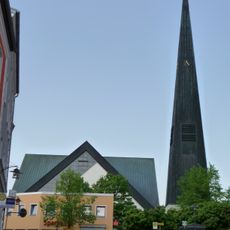
St. Johannes der Täufer
1.7 km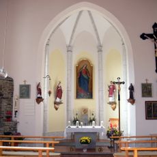
Chapel in Kasberg
734 m
Türgewände
1.7 km
Türgewände
1.7 km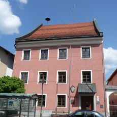
Rathaus, ehemaliges Landgericht
1.7 km
Torbogen
1.7 km
Kleinbauernhaus
758 m
Türgewände
1.6 km
Wohnhaus
1.7 km
Wohnstall- und Ausnahmshaus
500 m
Türgewände
1.7 km
Wohn- und Geschäftshaus
1.7 km
Gasthaus zur Linde
1.8 km
Wohnhaus
1.6 km
Wohnhaus
1.7 km
Haustür mit Türblatt und Gewände
1.7 km
Ehemaliges Bezirksamt
1.7 km
Türgewände
1.7 km
Bildstock
1.6 km
Arma-Christi-Kreuz
1.6 km
Wohnhaus eines Vierseithofes
1.7 km
Bildstock
875 m
Remise Marktstraße 31 in Wegscheid
1.7 km
Wohnhaus des Vierseithofes
1.7 km
Torbogen
1.6 km
Wayside cross
1.7 km
Wayside cross
705 mVisited this place? Tap the stars to rate it and share your experience / photos with the community! Try now! You can cancel it anytime.
Discover hidden gems everywhere you go!
From secret cafés to breathtaking viewpoints, skip the crowded tourist spots and find places that match your style. Our app makes it easy with voice search, smart filtering, route optimization, and insider tips from travelers worldwide. Download now for the complete mobile experience.

A unique approach to discovering new places❞
— Le Figaro
All the places worth exploring❞
— France Info
A tailor-made excursion in just a few clicks❞
— 20 Minutes