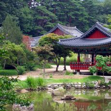
Yongin-bong, Berggipfel in Südkorea
Location: Gangwon Province
GPS coordinates: 37.08194,129.17667
Latest update: October 28, 2025 23:02

Bulyeongsa Temple
18 km
365 Safe Town
13.7 km
High1 Choochoopark
16.5 km
사랑바위
17.5 km
연화폭포
18.3 km
오로라파크
15.9 km
통리탄탄파크
14.7 km
도계유리마을
17.9 km
Scenic viewpoint
16.8 km
Scenic viewpoint
15.9 km
Mi-In Fall
15.8 km
흥전벽화마을
19 km
태양의후예 세트장
14.8 km
Scenic viewpoint
5.8 km
Scenic viewpoint
5.8 km
Scenic viewpoint
9.7 km
Scenic viewpoint
9.7 km
문필봉전망대
13 km
자유수호의탑 (Jayusuhouitap)
16.8 km
증기기관차
16.6 km
나한정 스위치백트레인 플랫폼
18.2 km
흥전역 스위치백 구간
19 km
Monument
17.3 km
충혼탑
16.5 km
울진현동도로준공기념탑
18.2 km
Memorial
17.1 km
위령사
19 km
울진민간인 희생자 위령비
19 kmReviews
Visited this place? Tap the stars to rate it and share your experience / photos with the community! Try now! You can cancel it anytime.
Discover hidden gems everywhere you go!
From secret cafés to breathtaking viewpoints, skip the crowded tourist spots and find places that match your style. Our app makes it easy with voice search, smart filtering, route optimization, and insider tips from travelers worldwide. Download now for the complete mobile experience.

A unique approach to discovering new places❞
— Le Figaro
All the places worth exploring❞
— France Info
A tailor-made excursion in just a few clicks❞
— 20 Minutes