Bannu Tehsil, tehsil in the namesake district of Khyber Pakhtunkhwa
Location: Bannu District
Elevation above the sea: 295 m
GPS coordinates: 32.92147,70.71693
Latest update: October 29, 2025 00:06

Forward Operating Base Chapman
84.8 km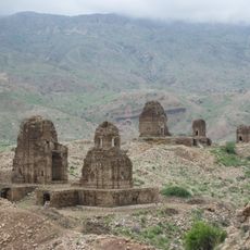
Kafir Kot
74.4 km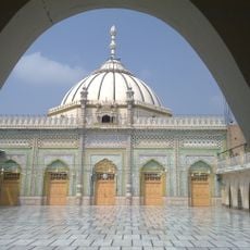
Thal Gumbad Mosque
51.5 km
Delemela road
62.2 km
Shakardara road
62.3 km
Teri, Khyper Pakhtunkhwa, Pakistan
55.1 km
Akhtar's house, Zarin Killa, Takht-e-Nasrati
26.6 km
Mamunh Khwarra
52.7 km
Thall Fort
51 km
Bannu Woollen Mills
11.6 km
Kabir kalla
62.1 km
Akhtar's house, Zarin Killa
26.6 km
Sanrri Thanrrakai
55.8 km
Village Barbara Banda
55.3 km
Cheshmay Baba Tea-Shop
34 km
Taimoor father's grave
55.6 km
Tomb of Bhor Sharif
56.3 km
Tomb of Pir Syed Kareem Haidar Shah
55.6 km
Shrine of Baba Saein Hameed Ullah Khan
58.4 km
Shrine of Munawwar Hussain Shah
60.1 km
حکیم ٹوپہ
49.8 km
Graveyard Barbara Banda ( قبرستان بربرہ بانڈہ)
55.7 km
Lala ki Qabar & Asif Shaheed grave
55.5 km
La La ki Qabar
55.4 km
Taimoor's grandfathers's grave
55.9 km
Taimoor'Grandpa's grave
55.9 km
Khan Badshah's grave
55.9 km
La La ki Qabar
55.4 kmReviews
Visited this place? Tap the stars to rate it and share your experience / photos with the community! Try now! You can cancel it anytime.
Discover hidden gems everywhere you go!
From secret cafés to breathtaking viewpoints, skip the crowded tourist spots and find places that match your style. Our app makes it easy with voice search, smart filtering, route optimization, and insider tips from travelers worldwide. Download now for the complete mobile experience.

A unique approach to discovering new places❞
— Le Figaro
All the places worth exploring❞
— France Info
A tailor-made excursion in just a few clicks❞
— 20 Minutes