Björnehögen, stenkammargrav i Småland (Gällaryd 21:1)
Location: Värnamo Municipality
GPS coordinates: 57.21565,14.31079
Latest update: November 13, 2025 13:34

Ohsabanan
2.9 km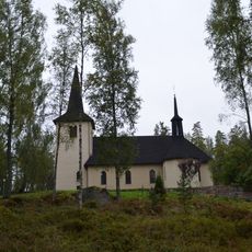
Ohs kyrka
2.5 km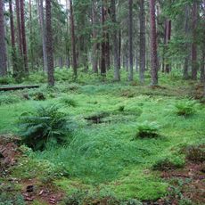
Doppebrunnen
5.4 km
Moens naturskog
4.4 km
Brunnstorp
2.3 km
Nydala 7:3
3.3 km
Gällaryd 108:1
6.2 km
Nydala 6:2
3.4 km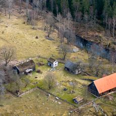
Moens gård
5.6 km
Nydala 7:2
3.3 km
Nydala 33:2
6.4 km
Bruksmuseet Ohs bruk
2.8 km
Nydala 6:1
3.4 km
Nydala 7:1
3.3 km
Fryele 145:1
6.4 km
Fryele 19:1
6.1 km
Johannesberg
4.7 km
Fryele 149:1
6.3 km
Fryele 148:1
6.3 km
Nydala 1:1
6.9 km
Nydala 3:1
4.2 km
Nydala 33:1
6.4 km
Fryele 23:1
4 km
Fryele 20:1
5.9 km
Gällaryd 31:1
5.7 km
Pengaröret
5.1 km
Gällaryd 22:1
1.3 km
Fryele 145:2
6.4 kmReviews
Visited this place? Tap the stars to rate it and share your experience / photos with the community! Try now! You can cancel it anytime.
Discover hidden gems everywhere you go!
From secret cafés to breathtaking viewpoints, skip the crowded tourist spots and find places that match your style. Our app makes it easy with voice search, smart filtering, route optimization, and insider tips from travelers worldwide. Download now for the complete mobile experience.

A unique approach to discovering new places❞
— Le Figaro
All the places worth exploring❞
— France Info
A tailor-made excursion in just a few clicks❞
— 20 Minutes