Gärdhem 288, hällristning i Västergötland
Location: Trollhättan Municipality
GPS coordinates: 58.24333,12.25155
Latest update: November 23, 2025 00:24
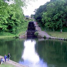
Trollhättan old locks
2.4 km
Åkerström
2.3 km
Ryrbäcken
1.5 km
Trollhättan 160:1
2.6 km
Trollhättan 53:4
2.6 km
Trollhättan 53:2
2.5 km
Gärdhem 73:1
1.5 km
Gärdhem 75:2
2.9 km
Gärdhem 79:2
43 m
Gärdhem 79:3
67 m
Gärdhem 69:1
2.7 km
Trollhättan 161:1
2 km
Gärdhem 69:2
2.7 km
Gärdhem 276
922 m
Hjärtum 201:1
2.6 km
Gärdhem 275
922 m
Trollhättan 53:1
2.5 km
Gärdhem 69:4
2.7 km
Trollhättan 52:1
2.7 km
Hjärtum 102:1
2.9 km
Trollhättan 297
2.7 km
Gärdhem 69:3
2.7 km
Lindvedens församlingshem
821 m
Hörlycke golfbana
972 m
Portal
2.8 km
Arkiv
2.8 km
Scenic viewpoint
2.4 km
Scenic viewpoint
2.5 kmReviews
Visited this place? Tap the stars to rate it and share your experience / photos with the community! Try now! You can cancel it anytime.
Discover hidden gems everywhere you go!
From secret cafés to breathtaking viewpoints, skip the crowded tourist spots and find places that match your style. Our app makes it easy with voice search, smart filtering, route optimization, and insider tips from travelers worldwide. Download now for the complete mobile experience.

A unique approach to discovering new places❞
— Le Figaro
All the places worth exploring❞
— France Info
A tailor-made excursion in just a few clicks❞
— 20 Minutes