Collins, locality in Manjimup, Western Australia, Australia
Location: Shire of Manjimup
Location: Western Australia
GPS coordinates: -34.43453,116.12393
Latest update: November 24, 2025 11:16
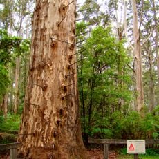
Gloucester Tree
6.1 km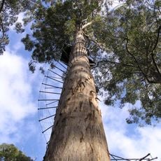
Dave Evans Bicentennial Tree
15.2 km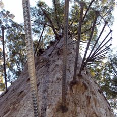
Diamond Tree
12.7 km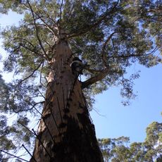
Gloucester National Park
6.1 km
Warren National Park
15.6 km
Pemberton Tramway Company
8.4 km
Brockman National Park
14.7 km
Sir James Mitchell National Park
10.9 km
Warren River Railway Bridge, Picton to Northcliffe Railway
9.6 km
Pemberton Swimming Pool
8.5 km
Pemberton Timber Mill Workers' Cottages Precinct
8.4 km
Pemberton Uniting Church
8.4 km
Big Brook Forest Arboretum
11.5 km
Mill Manager's House
8.5 km
Pemberton-Northcliffe Railway & Railway Station
14.6 km
Mill Workers' Hall
8.7 km
Gloucester Tree
6.3 km
Pemberton Golf Club
8.1 km
Big Brook Dam
9.2 km
Big Karri
11.1 km
Big Tree
13.4 km
Collins Apple Farm
3.4 km
Gnome Village
11.3 km
Silt artistry
11.6 km
Dave Evans Bicentennial Tree
15.2 km
Diamond Tree Lookout
12.7 km
Warren River Cedar
11.3 km
Cascades
9.7 kmReviews
Visited this place? Tap the stars to rate it and share your experience / photos with the community! Try now! You can cancel it anytime.
Discover hidden gems everywhere you go!
From secret cafés to breathtaking viewpoints, skip the crowded tourist spots and find places that match your style. Our app makes it easy with voice search, smart filtering, route optimization, and insider tips from travelers worldwide. Download now for the complete mobile experience.

A unique approach to discovering new places❞
— Le Figaro
All the places worth exploring❞
— France Info
A tailor-made excursion in just a few clicks❞
— 20 Minutes