Nisbet Trails Recreation Site, recreation site in Saskatchewan, Canada
Location: Buckland No. 491
GPS coordinates: 53.24217,-105.95282
Latest update: November 24, 2025 06:59
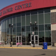
Art Hauser Centre
16 km
Rotary Museum of Police and Corrections
14.7 km
St. Louis Bridge
36.6 km
Nisbet Provincial Forest
13.5 km
South Branch House
39.6 km
Diefenbaker House
14 km
Keyhole Castle
14.4 km
Land Titles Building
14.5 km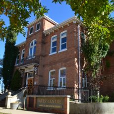
Prince Albert Arts Centre
13.7 km
The Evolution of Education Museum
14.7 km
Prince Albert Historical Museum
13.8 km
Diefenbaker Bridge
13.3 km
Canadian Northern Railway Bridge
13.4 km
Muskoday Bridge
35 km
Canwood Provincial Forest
38.5 km
Emma Lake (Murray Point) Recreation Site
40.3 km
Sturgeon River Recreation Site
5.6 km
Sturgeon Lake Regional Park
24.1 km
Canwood Regional Park
41.5 km
Buckland Wildlife Management Unit
12.4 km
Cooke Municipal Golf Course
16.1 km
Kachur's Golf Club
4.7 km
Emma Lake Golf Course
36.4 km
Kinsmen Water Slides & Pool
14.4 km
Mann Art Gallery
13.7 km
Murray Point Day Use Beach
41 km
Neis Beach
37.3 km
Scenic viewpoint, tower, Observation tower
10.3 kmReviews
Visited this place? Tap the stars to rate it and share your experience / photos with the community! Try now! You can cancel it anytime.
Discover hidden gems everywhere you go!
From secret cafés to breathtaking viewpoints, skip the crowded tourist spots and find places that match your style. Our app makes it easy with voice search, smart filtering, route optimization, and insider tips from travelers worldwide. Download now for the complete mobile experience.

A unique approach to discovering new places❞
— Le Figaro
All the places worth exploring❞
— France Info
A tailor-made excursion in just a few clicks❞
— 20 Minutes