Pasquia Regional Park, regional park in Saskatchewan, Canada
Location: Arborfield No. 456
GPS coordinates: 53.18892,-103.57963
Latest update: November 24, 2025 07:27
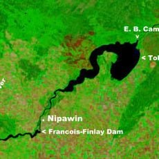
Tobin Lake
44.2 km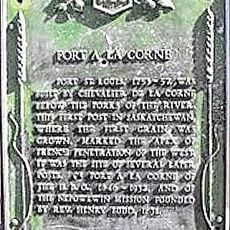
Fort de la Corne
81.5 km
Greenwater Lake Provincial Park
73.3 km
Beth Israel Synagogue
53 km
Crooked Bridge
36.4 km
Wildcat Hill Provincial Park
73.4 km
Nipawin Regional Park
36.2 km
Wapiti Valley Regional Park
58.8 km
Maurice Street Protected Area
38.2 km
Melfort and District Regional Park
77.4 km
Dragline Channel Recreation Site
83.2 km
Nipawin and District Regional Park
36.2 km
Fir River Road Recreation Site
62.2 km
D. Gerbrandt Recreation Site
57.9 km
Tisdale and District Regional Park
50.4 km
Wapiti Recreation Site
59.7 km
Kipabiskau Regional Park
79.1 km
Horsehide Lake Wildlife Management Unit
50.9 km
Neely Lake Game Preserve
74.1 km
Fort-à-la-Corne Wildlife Management Unit
76.5 km
Cadotte Rapids
39.6 km
Anderson Island Protected Area
75.8 km
Torch River Provincial Forest
52.3 km
Nipawin Rapids
35.8 km
Tobin Lake Recreation Site
39.5 km
Greenbush River Recreation Site
70.7 km
Neely Lake Migratory Bird Sanctuary
74.1 km
Melfort Golf and Country Club
77.8 kmReviews
Visited this place? Tap the stars to rate it and share your experience / photos with the community! Try now! You can cancel it anytime.
Discover hidden gems everywhere you go!
From secret cafés to breathtaking viewpoints, skip the crowded tourist spots and find places that match your style. Our app makes it easy with voice search, smart filtering, route optimization, and insider tips from travelers worldwide. Download now for the complete mobile experience.

A unique approach to discovering new places❞
— Le Figaro
All the places worth exploring❞
— France Info
A tailor-made excursion in just a few clicks❞
— 20 Minutes