Torsåker 2100, husgrund, historisk tid i Gästrikland
Location: Hofors Municipality
GPS coordinates: 60.52219,16.40635
Latest update: November 24, 2025 02:56
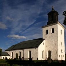
Torsåkers kyrka, Gästrikland
3.8 km
Söderåsen, Hofors kommun
2.2 km
Hammarby kapell
9.3 km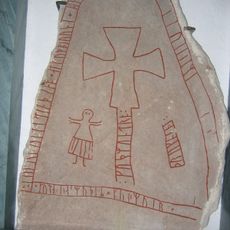
Gästriklands runinskrifter 7
3.8 km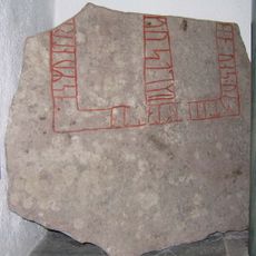
Gästriklands runinskrifter 8
3.8 km
Erkas
5.9 km
Hohällans domänreservat
9.2 km
Igeltjärnsberget
6.7 km
Solbergadalens domänreservat
8.8 km
Hofors hembygdsgård
6.8 km
Stiftelsen Gamla stenhuset
9.2 km
Malmjärn, public beach
8.4 km
Torsåker 1976
8.1 km
Torsåker 1:2
5.8 km
Torsåker 65:2
3 km
Torsåker 26:1
7.9 km
Torsåker 80:1
7.8 km
Smivretestorpet eller Smivreten
5.7 km
Korsgravarna
4.1 km
Torsåker 65:1
3 km
Torsåker 55:1
2.1 km
Vibygge fäbodar
9.2 km
Torsåker 54:1
3 km
Torsåker 1:1
5.9 km
Grabbo fäbodar
9.6 km
Torsåkers socken- och skolmuseum
3.7 km
Work of art
7.1 km
Work of art
6.8 kmReviews
Visited this place? Tap the stars to rate it and share your experience / photos with the community! Try now! You can cancel it anytime.
Discover hidden gems everywhere you go!
From secret cafés to breathtaking viewpoints, skip the crowded tourist spots and find places that match your style. Our app makes it easy with voice search, smart filtering, route optimization, and insider tips from travelers worldwide. Download now for the complete mobile experience.

A unique approach to discovering new places❞
— Le Figaro
All the places worth exploring❞
— France Info
A tailor-made excursion in just a few clicks❞
— 20 Minutes