Vetlanda 337, stenkrets i Småland
Location: Vetlanda Municipality
GPS coordinates: 57.43012,15.10601
Latest update: November 23, 2025 03:58

Vetlanda Church
1.9 km
Byestads gravfält
1 km
Vetlanda museum
1.4 km
Stora Illharjen
1.8 km
Östra Njudungs tingslag
1.9 km
Östra härads domsaga
1.9 km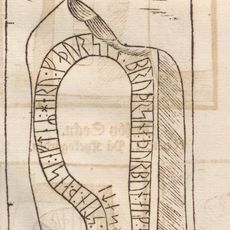
Smålands runinskrifter 110
1.5 km
Saga
1.3 km
Sm 108, Vetlanda kyrkogård
1.9 km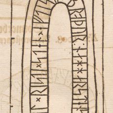
Sm 109, Vetlanda "klockarestuga"
1.9 km
Vetlanda 113:1
1.3 km
Vetlanda 55:1
1.2 km
Vetlanda 45:3
207 m
Vetlanda skolmuseum
1.1 km
Vetlanda 148:1
1.6 km
Njudungs hembygdsmuseum
1.1 km
Vetlanda 32:2
1.3 km
Vetlanda 67:2
1.6 km
Vetlanda 45:1
202 m
Vetlanda 67:1
1.6 km
Vetlanda 45:2
234 m
Vetlanda 32:3
1.3 km
Vetlanda 31:1
1.4 km
Sollinska huset
1.5 km
Svedbomska villan
1.1 km
Vetlanda 32:1
1.3 km
Vetlanda 113:3
1.2 km
Vetlanda 31:2
1.3 kmReviews
Visited this place? Tap the stars to rate it and share your experience / photos with the community! Try now! You can cancel it anytime.
Discover hidden gems everywhere you go!
From secret cafés to breathtaking viewpoints, skip the crowded tourist spots and find places that match your style. Our app makes it easy with voice search, smart filtering, route optimization, and insider tips from travelers worldwide. Download now for the complete mobile experience.

A unique approach to discovering new places❞
— Le Figaro
All the places worth exploring❞
— France Info
A tailor-made excursion in just a few clicks❞
— 20 Minutes