Lur 172:1, hällristning i Bohuslän
Location: Tanum Municipality
GPS coordinates: 58.82110,11.31381
Latest update: November 24, 2025 07:30
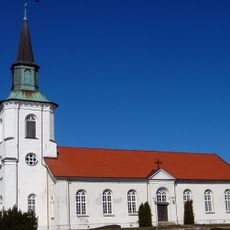
Lurs kyrka
1 km
Lur 84:1
992 m
Lur 141:3
926 m
Lur 86:1
954 m
Lur 46:2
1.2 km
Lur 83:2
762 m
Lur 353:1
1.1 km
Lur 130:1
1.1 km
Lur 131:2
1.1 km
Lur 209:1
927 m
Lur 85:1
834 m
Lur 85:2
818 m
Lur 47:2
745 m
Lur 428:1
193 m
Lur 140:1
1 km
Lur 140:2
1 km
Lur 141:2
906 m
Lur 46:3
1.2 km
Lur 131:1
1.1 km
Lur 83:1
789 m
Lur 137:1
375 m
Lur 423:1
1 km
Lur 90:1
1 km
Lur 87:1
1.1 km
Lur 47:1
743 m
Lur 46:1
1.2 km
Lur 233:1
960 m
Lur 88:1
832 mReviews
Visited this place? Tap the stars to rate it and share your experience / photos with the community! Try now! You can cancel it anytime.
Discover hidden gems everywhere you go!
From secret cafés to breathtaking viewpoints, skip the crowded tourist spots and find places that match your style. Our app makes it easy with voice search, smart filtering, route optimization, and insider tips from travelers worldwide. Download now for the complete mobile experience.

A unique approach to discovering new places❞
— Le Figaro
All the places worth exploring❞
— France Info
A tailor-made excursion in just a few clicks❞
— 20 Minutes