Medåker 174:1, stone setting in Västmanland, Sweden
Location: Arboga Municipality
GPS coordinates: 59.45851,15.81679
Latest update: November 10, 2025 22:32
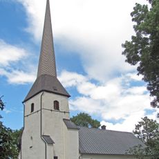
Medåkers kyrka
3.5 km
Medåker 58:1
2.6 km
Kurboberget (RAÄ 122)
2.6 km
Himmeta 18:1
3.3 km
Medåker 22:3
1 km
Medåker 15:1
3.7 km
Medåker 173:1
217 m
Medåker 83:1
3 km
Himmeta 30:1
1.3 km
Himmeta 33:1
1.1 km
Himmeta 33:2
1.2 km
Himmeta 46:1
1.2 km
Oxhagen
2.3 km
Medåker 68:1
3.5 km
Medåker 3:1
2.7 km
Kämplingen
2 km
Kurboberget (RAÄ 122)
2.6 km
Himmeta 18:2
3.3 km
Medåker 58:2
2.6 km
Medåker 22:1
1 km
Medåker 22:2
1 km
Himmeta 11:1
3.4 km
Medåker 23:1
1.2 km
Himmeta 11:2
3.5 km
Kurboberget (RAÄ 122)
2.6 km
Himmeta 25:1
1.5 km
Arboga socken 136
3.8 km
Himmeta 26:1
1.4 kmReviews
Visited this place? Tap the stars to rate it and share your experience / photos with the community! Try now! You can cancel it anytime.
Discover hidden gems everywhere you go!
From secret cafés to breathtaking viewpoints, skip the crowded tourist spots and find places that match your style. Our app makes it easy with voice search, smart filtering, route optimization, and insider tips from travelers worldwide. Download now for the complete mobile experience.

A unique approach to discovering new places❞
— Le Figaro
All the places worth exploring❞
— France Info
A tailor-made excursion in just a few clicks❞
— 20 Minutes