29, The Street, building in Wittersham, Ashford, Kent, UK
Location: Wittersham
Address: 29, The Street, Wittersham, Ashford, Kent, TN30
GPS coordinates: 51.01122,0.70402
Latest update: November 23, 2025 11:42
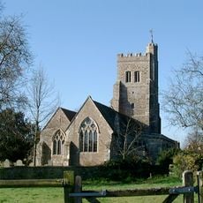
Parish Church of St John the Baptist
57 m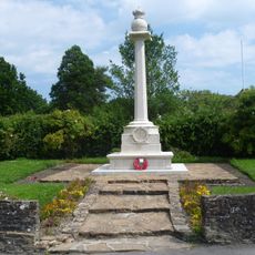
Wittersham War Memorial
405 m
Finches
675 m
Old Queens
111 m
Wittersham House
73 m
Wittersham Court
59 m
33, The Street
22 m
The Hamel
490 m
Mill House
482 m
Kings Mill
110 m
Wittersham Manor
823 m
Martens
360 m
39, The Street
90 m
8 And 8A, The Street
195 m
Poplar
505 m
21, Swan Street
472 m
Oasthouse At Budd's Farm Situated To North Of Farmhouse
580 m
The Homestead
349 m
The Ewe And Lamb Inn
448 m
Island Cottage
507 m
Budd's Farmhouse
625 m
3, 5 And 7, Poplar Road
406 m
Corner Cottage The White Cottage
608 m
Furners
222 m
Oxney House
132 m
20, Swan Street
523 m
The Corner Stores
427 m
29, Swan Street
493 mReviews
Visited this place? Tap the stars to rate it and share your experience / photos with the community! Try now! You can cancel it anytime.
Discover hidden gems everywhere you go!
From secret cafés to breathtaking viewpoints, skip the crowded tourist spots and find places that match your style. Our app makes it easy with voice search, smart filtering, route optimization, and insider tips from travelers worldwide. Download now for the complete mobile experience.

A unique approach to discovering new places❞
— Le Figaro
All the places worth exploring❞
— France Info
A tailor-made excursion in just a few clicks❞
— 20 Minutes