Headmaster's House, house in Mole Valley, Surrey, UK
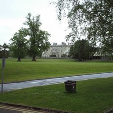
Ashtead Park
335 m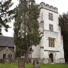
Church of St Giles, Ashtead
370 m
Bridgman Monument Approximately 8 Metres South Of Corner Of Chancel Of Church Of St Giles
369 m
Hamelot Monument Approximately 18 Metres South East Of Chancel Of Church Of St Giles
359 m
Bridge At Rookery Hill
285 m
Former Farm Building Approximately 2 Metres East Of Former Dairy Attached To Rear Of Park Farm House
400 m
Two Tomb Chests Approximately 27 Metres South Of Church Of St Giles
396 m
Ashtead House
108 m
Coal Tax Post At Tq 200 579
607 m
Ashtead Park House And Attached Balustrades
344 m
Row Of 7 Headstones And 4 Footstones From Approximately 17 To Approximately 25 Metres South Of Church Of St Giles
393 m
Garden Wall With Gateway And Gate Approximately 6 Metres In Front Of Ashstead Farm House
387 m
Wheldon Headstone Approximately 8 Metres East Of Chancel Of Church Of St Giles
355 m
Kitchen Garden Wall And Cottage
702 m
Walls And Balustrades To Terraced Garden On North Side Of Ashtead Park House
319 m
Sundial In Centre Of Forecourt In Front Of South Front Of Ashtead Park House
365 m
Gate Piers And Gates To Ashtead Park At Juncton Of Farm Lane And Pleasure Pit
48 m
Earthworks near St Giles' Church
382 m
Ashtead Park Farm House
394 m
Group Of 4 Headstones And 1 Footstone Approximately 2 Metres South West Of Porch Of Church Of St Giles
386 m
Coal Tax Post Near Junction With Headley Road
318 m
Balustrade Enclosing Forecourt In Front Of South Front Of Ashtead Park House
359 m
Stable Block Approximately 100 Metres West Of Ashtead Park House
400 m
Monument 5 Metres South Of Chancel Of Church Of St Giles
377 m
Group Of 7 Headstones And 5 Footstones From Approximately 17 To Approximately 25 Metres South Of Church Of St Giles
402 m
Ice House In Grounds Of Marsden Nurseries, Approximately 140 Metres North East Of Ashtead House
255 m
Walls Enclosing Walled Garden Beside Lane Opposite Ashtead House And North Of Headmasters House
153 m
Gatepiers With Associated Gates And Railings At Entrances To Rookery Hill And Drive To Church Of St Giles
536 mReviews
Visited this place? Tap the stars to rate it and share your experience / photos with the community! Try now! You can cancel it anytime.
Discover hidden gems everywhere you go!
From secret cafés to breathtaking viewpoints, skip the crowded tourist spots and find places that match your style. Our app makes it easy with voice search, smart filtering, route optimization, and insider tips from travelers worldwide. Download now for the complete mobile experience.

A unique approach to discovering new places❞
— Le Figaro
All the places worth exploring❞
— France Info
A tailor-made excursion in just a few clicks❞
— 20 Minutes