Coolah Golf Course
Location: Coolah
Location: Warrumbungle Shire Council
GPS coordinates: -31.81845,149.71813
Latest update: November 21, 2025 04:54

Old Police Station and Courthouse, Coolah
761 m
Weetalibah Nature Reserve
16.1 km
Horne Park
27 km
Bowen Oval
362 m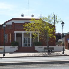
Coolah Library
603 m
Bryan Egan Weir
17.3 km
Bottom Weir
17.3 km
Scenic viewpoint
6.6 km
Cunninghams Camp Monument
19.4 km
Pandora Gallery
613 m
Scenic viewpoint
28.8 km
Scenic viewpoint
28.9 km
Scenic viewpoint
30.7 km
Pandora Pass
22 km
Grass Trees
30.2 km
Cox's Creek Sawmill
29.6 km
Cunningham and Leichhardt
19.6 km
Memorial, commemorative plaque
28.9 km
Neptune - Solar System Drive
1.1 km
Sir Ivan Fire memorial
25.7 km
Black Stump Rest Area
8.2 km
Memorial
8.2 km
War memorial, memorial
771 m
Norfolk Falls
28.9 km
Bald Hill's Falls
28.7 km
Iron Pots Waterfall
29.9 km
Coxs Creek Falls
29.1 km
Waterfall
29.1 kmReviews
Visited this place? Tap the stars to rate it and share your experience / photos with the community! Try now! You can cancel it anytime.
Discover hidden gems everywhere you go!
From secret cafés to breathtaking viewpoints, skip the crowded tourist spots and find places that match your style. Our app makes it easy with voice search, smart filtering, route optimization, and insider tips from travelers worldwide. Download now for the complete mobile experience.

A unique approach to discovering new places❞
— Le Figaro
All the places worth exploring❞
— France Info
A tailor-made excursion in just a few clicks❞
— 20 Minutes