Waubra Wind Farm Information
Location: Waubra
Location: Shire of Pyrenees
GPS coordinates: -37.35285,143.63132
Latest update: November 22, 2025 20:30
Clunes Post Office
15.3 km
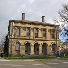
Clunes Town Hall and Court House
15.1 km
Mount Misery
5.6 km
Alexander Park
10.6 km
Mount Ercildoun
6.4 km
Quoin Hill
2.6 km
Big Hill
3.3 km
Lady Mount
7.9 km
Mt Mitchell Homestead and Stables
9.4 km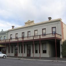
Club Hotel
15.2 km
ES&A Bank building, Clunes
15.2 km
Stony Creek School Reserve
14.5 km
Former St Pauls Church of England
14.9 km
Hamlin Pipe Organ
14.9 km
Ercildoun
7.5 km
Major Mitchell
13.3 km
Clunes Golf Course
13.2 km
Quoin Hill Vineyard
3.3 km
Scenic viewpoint
8.3 km
Scenic viewpoint
8.3 km
Lexton Golf Club
12.3 km
Memorial, streetlight
13.5 km
Goods Shed
1.3 km
Goods shed
11.9 km
Goods shed
13.4 km
Railway Monument
12.2 km
James Scullin's Birthplace
15 km
Ruins
13.3 kmReviews
Visited this place? Tap the stars to rate it and share your experience / photos with the community! Try now! You can cancel it anytime.
Discover hidden gems everywhere you go!
From secret cafés to breathtaking viewpoints, skip the crowded tourist spots and find places that match your style. Our app makes it easy with voice search, smart filtering, route optimization, and insider tips from travelers worldwide. Download now for the complete mobile experience.

A unique approach to discovering new places❞
— Le Figaro
All the places worth exploring❞
— France Info
A tailor-made excursion in just a few clicks❞
— 20 Minutes