Kapunda Historic Mine
Location: Kapunda
Location: Light Regional Council
GPS coordinates: -34.34900,138.91778
Latest update: November 22, 2025 11:13
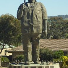
Map the Miner
1.1 km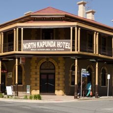
North Kapunda Hotel
946 m
Mount Allen
8.8 km
Luther Park
14.1 km
Robinson Park
13.8 km
Arthur Reusch Park
14.5 km
Heinemann Park
20.3 km
Gill Park
14.9 km
Black Hill
11 km
Coultyard Recreation Park
15.6 km
Stockwell Recreation Park
15.3 km
Barossa Bushgardens
15.8 km
Kapunda Reservoir
7.7 km
Stockport observatory
17.5 km
Stockport Golf Club
16.7 km
Kapunda Golf Club
2 km
Penfolds Barossa Valley Cellar Door
16.1 km
Peter Lehmann Wines
18.1 km
Langmeil Winery
18.2 km
Kapunda Ghost Tours
942 m
Barossa Valley Golf Club
10.8 km
Scenic viewpoint
2.1 km
Old Gilbert River Bridge
16.3 km
Memorial
20.1 km
Seppelt Family Mausoleum
15.3 km
Memorial, Obelisk
19.9 km
Monument
17.7 km
Monument
8.6 kmReviews
Visited this place? Tap the stars to rate it and share your experience / photos with the community! Try now! You can cancel it anytime.
Discover hidden gems everywhere you go!
From secret cafés to breathtaking viewpoints, skip the crowded tourist spots and find places that match your style. Our app makes it easy with voice search, smart filtering, route optimization, and insider tips from travelers worldwide. Download now for the complete mobile experience.

A unique approach to discovering new places❞
— Le Figaro
All the places worth exploring❞
— France Info
A tailor-made excursion in just a few clicks❞
— 20 Minutes